Perales geodata
Perales (Zacatecas) is a populated place; located in Mexico in America/Mexico_City (GMT-6) time zone. With population of 537 people, there are 15796 cities with bigger population in this country. Compared to other cities in Mexico, 86.9% of cities are located further ↓South; 84.3% of cities are located further →East and 87.8% of cities have lower elevation than Perales. Note1


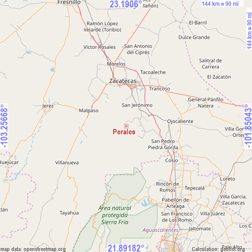
Perales GPS coordinates[2]
22° 32' 33.864" North, 102° 33' 12.78" West
| Map corner | latitude | longitude |
|---|---|---|
| Upper-left | 23.1906°, | -103.25668° |
| Center: | 22.54274°, | -102.55355° |
| Lower-right: | 21.89182°, | -101.85043° |
| Map W x H: | 144.4×144.4 km | = 89.7×89.7mi |
| max Lat: | 32.7° ⇑13.1% North |
| Perales: | 22.54274° |
| min Lat: | ⇓86.9% South 14.53588° |
| min Long | Perales | max Long |
| -117.105° | -102.55355° | -86.73105° |
| W 15.7%⇐ | ⇒84.3% E |
Elevation
Elevation of Perales is 2337 m = 7667 ft, and this is 1083.3 m = 3554 ft above average elevation for this country.
| Max E: |
3497 m = 11473 ft | 12.2% |
| Perales | 2337 m 7667 ft | |
| Avg. | 1253.7 m = 4113 ft | |
Min E: |
-1 m = -3 ft | 87.8% |
See also: Mexico elevation on elevation.city.
Geographical zone
Perales is located in North Torrid zone (between Equator and Tropic of Cancer). Distance of this Northern Tropic circle is 99.4 km =61.8 mi to North.| Distance of | km | miles | from Perales |
|---|---|---|---|
| North Pole | 7500.5 | 4660.6 | to North |
| Arctic Circle | 4894.7 | 3041.4 | to North |
| Tropic Cancer | 99.4 | 61.8 | to North |
| Equator | 2506.5 | 1557.5 | to South |


Nearby cities:
15 places around Perales: (largest is in red/bold)
• Bañuelos
12.6 km =7.8 mi,  18°
18°
• Cieneguitas
20 km =12.4 mi, 18°
• Colonia Río Verde
14.8 km =9.2 mi,  121°
121°
• Colonia San Isidro
11.4 km =7.1 mi,  130°
130°
• El Fuerte
22.8 km =14.2 mi,  302°
302°
• García de la Cadena
21.5 km =13.4 mi,  328°
328°
• Genaro Codina
11.6 km =7.2 mi, 121°
• González Ortega (Machines)
22 km =13.7 mi,  309°
309°
• Guadalupe
23 km =14.3 mi,  8°
8°
• La Zacatecana
22.4 km =13.9 mi, 21°
• Paso de Méndez
9.1 km =5.7 mi,  109°
109°
• San Jerónimo
13.9 km =8.6 mi,  27°
27°
• San Ramón
17.5 km =10.9 mi, 9°
• Santa Inés
6.7 km =4.2 mi,  91°
91°
• Tlacotes
22.8 km =14.2 mi,  81°
81°
Sources, notices
• [Note1] Compared only with cities in Mexico existing in our database
• [Src1] Map data: © OpenStreetMap contributors (CC-BY-SA)
• [Src2] Other city data from geonames.org with taken over terms of usage.
• [Src3] Geographical zone / Annual Mean Temperature by Robert A. Rohde @ Wikipedia
