Tacoaleche geodata
Tacoaleche (Zacatecas) is a populated place; located in Mexico in America/Mexico_City (GMT-6) time zone. With population of 8,612 people, there are 1106 cities with bigger population in this country. Compared to other cities in Mexico, 87.6% of cities are located further ↓South; 83.5% of cities are located further →East and 80% of cities have lower elevation than Tacoaleche. Note1


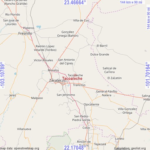
Tacoaleche GPS coordinates[2]
22° 49' 12.36" North, 102° 24' 17.136" West
| Map corner | latitude | longitude |
|---|---|---|
| Upper-left | 23.46664°, | -103.10789° |
| Center: | 22.8201°, | -102.40476° |
| Lower-right: | 22.17048°, | -101.70164° |
| Map W x H: | 144.1×144.1 km | = 89.5×89.5mi |
| max Lat: | 32.7° ⇑12.4% North |
| Tacoaleche: | 22.8201° |
| min Lat: | ⇓87.6% South 14.53588° |
| min Long | Tacoaleche | max Long |
| -117.105° | -102.40476° | -86.73105° |
| W 16.5%⇐ | ⇒83.5% E |
Elevation
Elevation of Tacoaleche is 2141 m = 7024 ft, and this is 887.3 m = 2911 ft above average elevation for this country.
| Max E: |
3497 m = 11473 ft | 20% |
| Tacoaleche | 2141 m 7024 ft | |
| Avg. | 1253.7 m = 4113 ft | |
Min E: |
-1 m = -3 ft | 80% |
See also: Mexico elevation on elevation.city.
Geographical zone
Tacoaleche is located in North Torrid zone (between Equator and Tropic of Cancer). Distance of this Northern Tropic circle is 68.6 km =42.6 mi to North.| Distance of | km | miles | from Tacoaleche |
|---|---|---|---|
| North Pole | 7469.7 | 4641.5 | to North |
| Arctic Circle | 4863.8 | 3022.2 | to North |
| Tropic Cancer | 68.6 | 42.6 | to North |
| Equator | 2537.4 | 1576.7 | to South |


Nearby cities:
15 places around Tacoaleche: (largest is in red/bold)
• Casa Blanca
12.3 km =7.6 mi,  54°
54°
• Casa de Cerros
13.9 km =8.6 mi,  301°
301°
• El Lampotal
8.6 km =5.3 mi,  349°
349°
• Guadalupe
14.2 km =8.8 mi,  235°
235°
• La Blanquita
4.5 km =2.8 mi,  141°
141°
• La Luz
11.8 km =7.3 mi,  55°
55°
• La Zacatecana
12.3 km =7.6 mi,  215°
215°
• Martínez Domínguez
11.2 km =7 mi, 224°
• San José de la Era
3.9 km =2.4 mi,  332°
332°
• San José del Carmen
14.6 km =9.1 mi,  114°
114°
• Santa Mónica
7.5 km =4.7 mi,  193°
193°
• Santa Rita
10.3 km =6.4 mi, 352°
• Sauceda de La Borda
10.1 km =6.3 mi,  276°
276°
• Trancoso
10.2 km =6.3 mi,  157°
157°
• Zoquite
4.3 km =2.7 mi,  205°
205°
Sources, notices
• [Note1] Compared only with cities in Mexico existing in our database
• [Src1] Map data: © OpenStreetMap contributors (CC-BY-SA)
• [Src2] Other city data from geonames.org with taken over terms of usage.
• [Src3] Geographical zone / Annual Mean Temperature by Robert A. Rohde @ Wikipedia
