Pimienta geodata
Pimienta (Zacatecas) is a populated place; located in Mexico in America/Mexico_City (GMT-6) time zone. With population of 819 people, there are 10664 cities with bigger population in this country. Compared to other cities in Mexico, 87.5% of cities are located further ↓South; 84.6% of cities are located further →East and 87.4% of cities have lower elevation than Pimienta. Note1


Pimienta GPS coordinates[2]
22° 47' 28.428" North, 102° 37' 55.164" West
| Map corner | latitude | longitude |
|---|---|---|
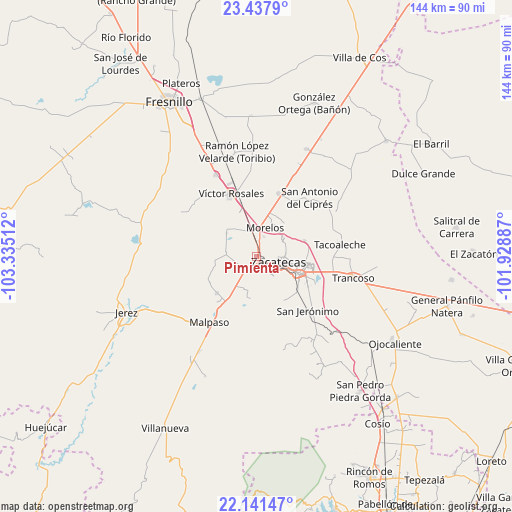
| Upper-left | 23.4379°, | -103.33512° |
| Center: | 22.79123°, | -102.63199° |
| Lower-right: | 22.14147°, | -101.92887° |
| Map W x H: | 144.1×144.2 km | = 89.5×89.6mi |
| max Lat: | 32.7° ⇑12.5% North |
| Pimienta: | 22.79123° |
| min Lat: | ⇓87.5% South 14.53588° |
| min Long | Pimienta | max Long |
| -117.105° | -102.63199° | -86.73105° |
| W 15.4%⇐ | ⇒84.6% E |
Elevation
Elevation of Pimienta is 2322 m = 7618 ft, and this is 1068.3 m = 3505 ft above average elevation for this country.
| Max E: |
3497 m = 11473 ft | 12.6% |
| Pimienta | 2322 m 7618 ft | |
| Avg. | 1253.7 m = 4113 ft | |
Min E: |
-1 m = -3 ft | 87.4% |
See also: Mexico elevation on elevation.city.
Geographical zone
Pimienta is located in North Torrid zone (between Equator and Tropic of Cancer). Distance of this Northern Tropic circle is 71.8 km =44.6 mi to North.| Distance of | km | miles | from Pimienta |
|---|---|---|---|
| North Pole | 7472.9 | 4643.4 | to North |
| Arctic Circle | 4867 | 3024.2 | to North |
| Tropic Cancer | 71.8 | 44.6 | to North |
| Equator | 2534.1 | 1574.6 | to South |


Nearby cities:
15 places around Pimienta: (largest is in red/bold)
• Benito Juárez
15.3 km =9.5 mi,  227°
227°
• Casa de Cerros
15.4 km =9.6 mi,  47°
47°
• Cieneguillas
4.9 km =3 mi,  219°
219°
• Francisco I. Madero
8.8 km =5.5 mi,  273°
273°
• García de la Cadena
10 km =6.2 mi,  199°
199°
• Guadalupe
12.6 km =7.8 mi,  112°
112°
• Hacienda Nueva
4.4 km =2.7 mi,  33°
33°
• Las Pilas
5.8 km =3.6 mi,  19°
19°
• Morelos
8.2 km =5.1 mi, 15°
• Picones
4.1 km =2.5 mi,  183°
183°
• Pánuco
13.3 km =8.3 mi,  44°
44°
• San Ramón
15.1 km =9.4 mi,  133°
133°
• Sauceda de La Borda
14 km =8.7 mi,  71°
71°
• Vetagrande
9.1 km =5.7 mi,  58°
58°
• Zacatecas
5.8 km =3.6 mi,  116°
116°
Sources, notices
• [Note1] Compared only with cities in Mexico existing in our database
• [Src1] Map data: © OpenStreetMap contributors (CC-BY-SA)
• [Src2] Other city data from geonames.org with taken over terms of usage.
• [Src3] Geographical zone / Annual Mean Temperature by Robert A. Rohde @ Wikipedia
