Zacatecas geodata
Zacatecas is a seat of a first-order administrative division; located in Mexico in America/Mexico_City (GMT-6) time zone. With population of 129,011 people, there are 112 cities with bigger population in this country. Compared to other cities in Mexico, 87.5% of cities are located further ↓South; 84.4% of cities are located further →East and 91.9% of cities have lower elevation than Zacatecas. Note1


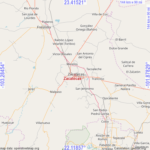
Zacatecas GPS coordinates[2]
22° 46' 6.348" North, 102° 34' 53.076" West
| Map corner | latitude | longitude |
|---|---|---|
| Upper-left | 23.41521°, | -103.28454° |
| Center: | 22.76843°, | -102.58141° |
| Lower-right: | 22.11857°, | -101.87829° |
| Map W x H: | 144.2×144.2 km | = 89.6×89.6mi |
| max Lat: | 32.7° ⇑12.5% North |
| Zacatecas: | 22.76843° |
| min Lat: | ⇓87.5% South 14.53588° |
| min Long | Zacatecas | max Long |
| -117.105° | -102.58141° | -86.73105° |
| W 15.6%⇐ | ⇒84.4% E |
Elevation
Elevation of Zacatecas is 2480 m = 8136 ft, and this is 1226.3 m = 4023 ft above average elevation for this country.
| Max E: |
3497 m = 11473 ft | 8.1% |
| Zacatecas | 2480 m 8136 ft | |
| Avg. | 1253.7 m = 4113 ft | |
Min E: |
-1 m = -3 ft | 91.9% |
See also: Zacatecas elevation on elevation.city.
Geographical zone
Zacatecas is located in North Torrid zone (between Equator and Tropic of Cancer). Distance of this Northern Tropic circle is 74.3 km =46.2 mi to North.| Distance of | km | miles | from Zacatecas |
|---|---|---|---|
| North Pole | 7475.4 | 4645 | to North |
| Arctic Circle | 4869.6 | 3025.8 | to North |
| Tropic Cancer | 74.3 | 46.2 | to North |
| Equator | 2531.6 | 1573.1 | to South |


Nearby cities:
15 places around Zacatecas: (largest is in red/bold)
• Cieneguillas
8.4 km =5.2 mi,  261°
261°
• Cieneguitas
10.9 km =6.8 mi,  123°
123°
• García de la Cadena
10.9 km =6.8 mi,  230°
230°
• Guadalupe
6.8 km =4.2 mi,  109°
109°
• Hacienda Nueva
6.8 km =4.2 mi,  336°
336°
• La Zacatecana
11.7 km =7.3 mi, 111°
• Las Pilas
8.6 km =5.3 mi, 337°
• Martínez Domínguez
10.5 km =6.5 mi,  102°
102°
• Morelos
10.8 km =6.7 mi, 343°
• Picones
5.6 km =3.5 mi,  253°
253°
• Pimienta
5.8 km =3.6 mi,  296°
296°
• Pánuco
12.7 km =7.9 mi,  19°
19°
• San Ramón
9.7 km =6 mi,  143°
143°
• Sauceda de La Borda
10.6 km =6.6 mi,  49°
49°
• Vetagrande
7.7 km =4.8 mi, 19°
Sources, notices
• [Note1] Compared only with cities in Mexico existing in our database
• [Src1] Map data: © OpenStreetMap contributors (CC-BY-SA)
• [Src2] Other city data from geonames.org with taken over terms of usage.
• [Src3] Geographical zone / Annual Mean Temperature by Robert A. Rohde @ Wikipedia
