San Ramón geodata
San Ramón (Zacatecas) is a populated place; located in Mexico in America/Mexico_City (GMT-6) time zone. With population of 667 people, there are 13011 cities with bigger population in this country. Compared to other cities in Mexico, 87.3% of cities are located further ↓South; 84.2% of cities are located further →East and 86.3% of cities have lower elevation than San Ramón. Note1


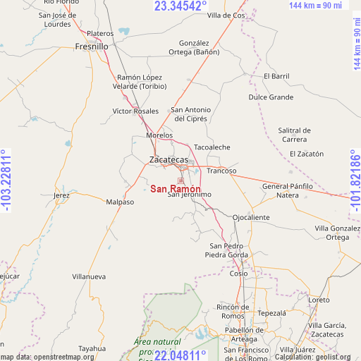
San Ramón GPS coordinates[2]
22° 41' 53.88" North, 102° 31' 29.928" West
| Map corner | latitude | longitude |
|---|---|---|
| Upper-left | 23.34542°, | -103.22811° |
| Center: | 22.6983°, | -102.52498° |
| Lower-right: | 22.04811°, | -101.82186° |
| Map W x H: | 144.2×144.2 km | = 89.6×89.6mi |
| max Lat: | 32.7° ⇑12.7% North |
| San Ramón: | 22.6983° |
| min Lat: | ⇓87.3% South 14.53588° |
| min Long | San Ramón | max Long |
| -117.105° | -102.52498° | -86.73105° |
| W 15.8%⇐ | ⇒84.2% E |
Elevation
Elevation of San Ramón is 2289 m = 7510 ft, and this is 1035.3 m = 3397 ft above average elevation for this country.
| Max E: |
3497 m = 11473 ft | 13.7% |
| San Ramón | 2289 m 7510 ft | |
| Avg. | 1253.7 m = 4113 ft | |
Min E: |
-1 m = -3 ft | 86.3% |
See also: Mexico elevation on elevation.city.
Geographical zone
San Ramón is located in North Torrid zone (between Equator and Tropic of Cancer). Distance of this Northern Tropic circle is 82.1 km =51 mi to North.| Distance of | km | miles | from San Ramón |
|---|---|---|---|
| North Pole | 7483.2 | 4649.8 | to North |
| Arctic Circle | 4877.4 | 3030.7 | to North |
| Tropic Cancer | 82.1 | 51 | to North |
| Equator | 2523.8 | 1568.2 | to South |


Nearby cities:
15 places around San Ramón: (largest is in red/bold)
• Bañuelos
5.4 km =3.4 mi,  169°
169°
• Cieneguillas
15.6 km =9.7 mi,  294°
294°
• Cieneguitas
3.7 km =2.3 mi,  62°
62°
• García de la Cadena
14.3 km =8.9 mi,  273°
273°
• Guadalupe
5.5 km =3.4 mi,  6°
6°
• La Zacatecana
6.3 km =3.9 mi, 55°
• Martínez Domínguez
7.1 km =4.4 mi,  39°
39°
• Picones
12.8 km =8 mi,  299°
299°
• Pimienta
15.1 km =9.4 mi,  313°
313°
• San Jerónimo
6 km =3.7 mi,  145°
145°
• Santa Mónica
12.3 km =7.6 mi, 59°
• Sauceda de La Borda
14.9 km =9.3 mi, 8°
• Vetagrande
15.4 km =9.6 mi,  348°
348°
• Zacatecas
9.7 km =6 mi,  323°
323°
• Zoquite
14.3 km =8.9 mi,  47°
47°
Sources, notices
• [Note1] Compared only with cities in Mexico existing in our database
• [Src1] Map data: © OpenStreetMap contributors (CC-BY-SA)
• [Src2] Other city data from geonames.org with taken over terms of usage.
• [Src3] Geographical zone / Annual Mean Temperature by Robert A. Rohde @ Wikipedia
