Guadalupe geodata
Guadalupe (Zacatecas) is a seat of a second-order administrative division; located in Mexico in America/Mexico_City (GMT-6) time zone. With population of 124,623 people, there are 115 cities with bigger population in this country. Compared to other cities in Mexico, 87.4% of cities are located further ↓South; 84.2% of cities are located further →East and 85.9% of cities have lower elevation than Guadalupe. Note1


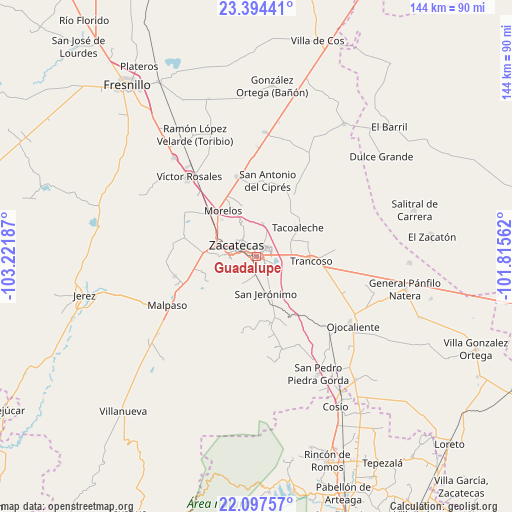
Guadalupe GPS coordinates[2]
22° 44' 51.108" North, 102° 31' 7.464" West
| Map corner | latitude | longitude |
|---|---|---|
| Upper-left | 23.39441°, | -103.22187° |
| Center: | 22.74753°, | -102.51874° |
| Lower-right: | 22.09757°, | -101.81562° |
| Map W x H: | 144.2×144.2 km | = 89.6×89.6mi |
| max Lat: | 32.7° ⇑12.6% North |
| Guadalupe: | 22.74753° |
| min Lat: | ⇓87.4% South 14.53588° |
| min Long | Guadalupe | max Long |
| -117.105° | -102.51874° | -86.73105° |
| W 15.8%⇐ | ⇒84.2% E |
Elevation
Elevation of Guadalupe is 2280 m = 7480 ft, and this is 1026.3 m = 3367 ft above average elevation for this country.
| Max E: |
3497 m = 11473 ft | 14.1% |
| Guadalupe | 2280 m 7480 ft | |
| Avg. | 1253.7 m = 4113 ft | |
Min E: |
-1 m = -3 ft | 85.9% |
See also: Guadalupe elevation on elevation.city.
Geographical zone
Guadalupe is located in North Torrid zone (between Equator and Tropic of Cancer). Distance of this Northern Tropic circle is 76.6 km =47.6 mi to North.| Distance of | km | miles | from Guadalupe |
|---|---|---|---|
| North Pole | 7477.8 | 4646.5 | to North |
| Arctic Circle | 4871.9 | 3027.3 | to North |
| Tropic Cancer | 76.6 | 47.6 | to North |
| Equator | 2529.3 | 1571.6 | to South |


Nearby cities:
15 places around Guadalupe: (largest is in red/bold)
• Bañuelos
10.8 km =6.7 mi,  178°
178°
• Cieneguitas
4.6 km =2.9 mi,  145°
145°
• Hacienda Nueva
12.6 km =7.8 mi,  313°
313°
• La Zacatecana
4.9 km =3 mi,  112°
112°
• Las Pilas
14.1 km =8.8 mi,  316°
316°
• Martínez Domínguez
3.9 km =2.4 mi,  89°
89°
• Picones
11.9 km =7.4 mi,  273°
273°
• Pimienta
12.6 km =7.8 mi,  292°
292°
• San Jerónimo
10.8 km =6.7 mi,  165°
165°
• San Ramón
5.5 km =3.4 mi,  186°
186°
• Santa Mónica
9.9 km =6.2 mi, 85°
• Sauceda de La Borda
9.4 km =5.8 mi,  10°
10°
• Vetagrande
10.4 km =6.5 mi,  338°
338°
• Zacatecas
6.8 km =4.2 mi, 289°
• Zoquite
10.7 km =6.6 mi,  66°
66°
Sources, notices
• [Note1] Compared only with cities in Mexico existing in our database
• [Src1] Map data: © OpenStreetMap contributors (CC-BY-SA)
• [Src2] Other city data from geonames.org with taken over terms of usage.
• [Src3] Geographical zone / Annual Mean Temperature by Robert A. Rohde @ Wikipedia
