Vetagrande geodata
Vetagrande (Zacatecas) is a populated place; located in Mexico in America/Mexico_City (GMT-6) time zone. With population of 1,093 people, there are 7958 cities with bigger population in this country. Compared to other cities in Mexico, 87.6% of cities are located further ↓South; 84.4% of cities are located further →East and 93.3% of cities have lower elevation than Vetagrande. Note1


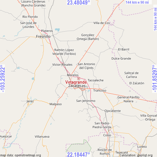
Vetagrande GPS coordinates[2]
22° 50' 2.472" North, 102° 33' 21.924" West
| Map corner | latitude | longitude |
|---|---|---|
| Upper-left | 23.48049°, | -103.25922° |
| Center: | 22.83402°, | -102.55609° |
| Lower-right: | 22.18447°, | -101.85297° |
| Map W x H: | 144.1×144.1 km | = 89.5×89.5mi |
| max Lat: | 32.7° ⇑12.4% North |
| Vetagrande: | 22.83402° |
| min Lat: | ⇓87.6% South 14.53588° |
| min Long | Vetagrande | max Long |
| -117.105° | -102.55609° | -86.73105° |
| W 15.6%⇐ | ⇒84.4% E |
Elevation
Elevation of Vetagrande is 2544 m = 8346 ft, and this is 1290.3 m = 4233 ft above average elevation for this country.
| Max E: |
3497 m = 11473 ft | 6.7% |
| Vetagrande | 2544 m 8346 ft | |
| Avg. | 1253.7 m = 4113 ft | |
Min E: |
-1 m = -3 ft | 93.3% |
See also: Mexico elevation on elevation.city.
Geographical zone
Vetagrande is located in North Torrid zone (between Equator and Tropic of Cancer). Distance of this Northern Tropic circle is 67 km =41.6 mi to North.| Distance of | km | miles | from Vetagrande |
|---|---|---|---|
| North Pole | 7468.2 | 4640.5 | to North |
| Arctic Circle | 4862.3 | 3021.3 | to North |
| Tropic Cancer | 67 | 41.6 | to North |
| Equator | 2538.9 | 1577.6 | to South |


Nearby cities:
15 places around Vetagrande: (largest is in red/bold)
• Casa de Cerros
6.7 km =4.2 mi,  32°
32°
• Cieneguillas
13.9 km =8.6 mi,  231°
231°
• Guadalupe
10.4 km =6.5 mi,  158°
158°
• Hacienda Nueva
5.5 km =3.4 mi,  258°
258°
• Las Pilas
5.8 km =3.6 mi,  276°
276°
• Martínez Domínguez
12.3 km =7.6 mi,  141°
141°
• Morelos
6.4 km =4 mi,  299°
299°
• Picones
12 km =7.5 mi,  222°
222°
• Pimienta
9.1 km =5.7 mi,  238°
238°
• Pozos de Gamboa
12.8 km =8 mi,  353°
353°
• Pánuco
4.9 km =3 mi,  18°
18°
• San Antonio del Cipres
13.6 km =8.5 mi, 31°
• San José de la Era
13.8 km =8.6 mi,  82°
82°
• Sauceda de La Borda
5.5 km =3.4 mi,  94°
94°
• Zacatecas
7.7 km =4.8 mi,  199°
199°
Sources, notices
• [Note1] Compared only with cities in Mexico existing in our database
• [Src1] Map data: © OpenStreetMap contributors (CC-BY-SA)
• [Src2] Other city data from geonames.org with taken over terms of usage.
• [Src3] Geographical zone / Annual Mean Temperature by Robert A. Rohde @ Wikipedia
