La Pila geodata
La Pila (San Luis Potosí) is a populated place; located in Mexico in America/Mexico_City (GMT-6) time zone. With population of 6,722 people, there are 1397 cities with bigger population in this country. Compared to other cities in Mexico, 84.4% of cities are located further ↓South; 72.4% of cities are located further →East and 66.9% of cities have lower elevation than La Pila. Note1


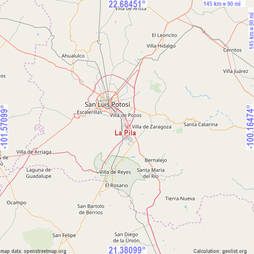
La Pila GPS coordinates[2]
22° 2' 3.3" North, 100° 52' 4.296" West
| Map corner | latitude | longitude |
|---|---|---|
| Upper-left | 22.68451°, | -101.57099° |
| Center: | 22.03425°, | -100.86786° |
| Lower-right: | 21.38099°, | -100.16474° |
| Map W x H: | 144.9×144.9 km | = 90×90mi |
| max Lat: | 32.7° ⇑15.6% North |
| La Pila: | 22.03425° |
| min Lat: | ⇓84.4% South 14.53588° |
| min Long | La Pila | max Long |
| -117.105° | -100.86786° | -86.73105° |
| W 27.6%⇐ | ⇒72.4% E |
Elevation
Elevation of La Pila is 1868 m = 6129 ft, and this is 614.3 m = 2015 ft above average elevation for this country.
| Max E: |
3497 m = 11473 ft | 33.1% |
| La Pila | 1868 m 6129 ft | |
| Avg. | 1253.7 m = 4113 ft | |
Min E: |
-1 m = -3 ft | 66.9% |
See also: Mexico elevation on elevation.city.
Geographical zone
La Pila is located in North Torrid zone (between Equator and Tropic of Cancer). Distance of this Northern Tropic circle is 155.9 km =96.9 mi to North.| Distance of | km | miles | from La Pila |
|---|---|---|---|
| North Pole | 7557.1 | 4695.8 | to North |
| Arctic Circle | 4951.2 | 3076.5 | to North |
| Tropic Cancer | 155.9 | 96.9 | to North |
| Equator | 2450 | 1522.4 | to South |


Nearby cities:
15 places around La Pila: (largest is in red/bold)
• Arroyos
4.5 km =2.8 mi,  300°
300°
• Bosques la Florida
12.8 km =8 mi,  5°
5°
• Cerro Gordo
9.2 km =5.7 mi,  136°
136°
• Ciudad Satélite
11.3 km =7 mi,  41°
41°
• El Jaralito
4.8 km =3 mi,  84°
84°
• El Terrero Sur
4.2 km =2.6 mi,  279°
279°
• Emiliano Zapata
13.4 km =8.3 mi,  200°
200°
• La Esperanza
11 km =6.8 mi,  105°
105°
• La Presa (La Presita)
13.2 km =8.2 mi,  205°
205°
• Laguna de San Vicente
9.8 km =6.1 mi,  174°
174°
• Laguna de Santa Rita
9.2 km =5.7 mi, 13°
• Los Gómez
13.4 km =8.3 mi,  353°
353°
• Noria San José
2.9 km =1.8 mi, 354°
• Panalillo
13.8 km =8.6 mi,  23°
23°
• Tanque el Jagüey
9.1 km =5.7 mi, 8°
Sources, notices
• [Note1] Compared only with cities in Mexico existing in our database
• [Src1] Map data: © OpenStreetMap contributors (CC-BY-SA)
• [Src2] Other city data from geonames.org with taken over terms of usage.
• [Src3] Geographical zone / Annual Mean Temperature by Robert A. Rohde @ Wikipedia
