Zapotillo geodata
Zapotillo (Jalisco) is a populated place; located in Mexico in America/Mexico_City (GMT-6) time zone. With population of 975 people, there are 8909 cities with bigger population in this country. Compared to other cities in Mexico, 51.2% of cities are located further ↑North; 90.9% of cities are located further →East and 71.4% of cities have higher elevation than Zapotillo. Note1


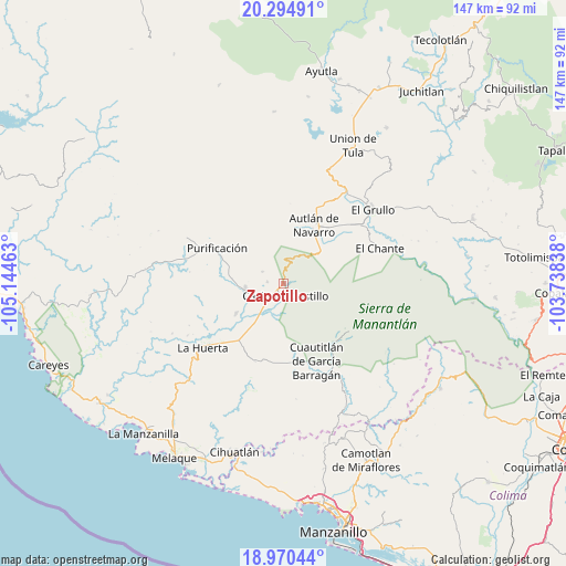
Zapotillo GPS coordinates[2]
19° 38' 2.544" North, 104° 26' 29.4" West
| Map corner | latitude | longitude |
|---|---|---|
| Upper-left | 20.29491°, | -105.14463° |
| Center: | 19.63404°, | -104.4415° |
| Lower-right: | 18.97044°, | -103.73838° |
| Map W x H: | 147.3×147.3 km | = 91.5×91.5mi |
| max Lat: | 32.7° ⇑51.2% North |
| Zapotillo: | 19.63404° |
| min Lat: | ⇓48.8% South 14.53588° |
| min Long | Zapotillo | max Long |
| -117.105° | -104.4415° | -86.73105° |
| W 9.1%⇐ | ⇒90.9% E |
Elevation
Elevation of Zapotillo is 353 m = 1158 ft, and this is 900.7 m = 2955 ft below average elevation for this country.
| Max E: |
3497 m = 11473 ft | 71.4% |
| Avg. | 1253.7 m = 4113 ft | |
| Zapotillo | 353 m = 1158 ft | |
Min E: |
-1 m = -3 ft | 28.6% |
See also: Mexico elevation on elevation.city.
Geographical zone
Zapotillo is located in North Torrid zone (between Equator and Tropic of Cancer). Distance of this Northern Tropic circle is 422.8 km =262.7 mi to North.| Distance of | km | miles | from Zapotillo |
|---|---|---|---|
| North Pole | 7824 | 4861.6 | to North |
| Arctic Circle | 5218.1 | 3242.4 | to North |
| Tropic Cancer | 422.8 | 262.7 | to North |
| Equator | 2183.1 | 1356.5 | to South |


Nearby cities:
15 places around Zapotillo: (largest is in red/bold)
• Ahuacapán
13.1 km =8.1 mi,  67°
67°
• Autlán de Navarro
16.9 km =10.5 mi,  27°
27°
• Coyamel (El Coyame)
17.4 km =10.8 mi,  209°
209°
• Cuautitlán
22.1 km =13.7 mi,  157°
157°
• Cuzalapa
20.1 km =12.5 mi,  138°
138°
• El Chico
14.5 km =9 mi,  237°
237°
• El Mentidero
21.7 km =13.5 mi,  45°
45°
• La Resolana
3.3 km =2.1 mi,  166°
166°
• Las Lagunillas
18.5 km =11.5 mi,  60°
60°
• Las Paredes
25.5 km =15.8 mi, 52°
• Lo Arado
9.8 km =6.1 mi,  261°
261°
• Mezquitán
23.6 km =14.7 mi, 27°
• Piedra Pesada
10 km =6.2 mi,  201°
201°
• Purificación
19.5 km =12.1 mi,  298°
298°
• Tecomates
10.4 km =6.5 mi, 206°
Sources, notices
• [Note1] Compared only with cities in Mexico existing in our database
• [Src1] Map data: © OpenStreetMap contributors (CC-BY-SA)
• [Src2] Other city data from geonames.org with taken over terms of usage.
• [Src3] Geographical zone / Annual Mean Temperature by Robert A. Rohde @ Wikipedia
