Cuautitlán geodata
Cuautitlán (Jalisco) is a seat of a second-order administrative division; located in Mexico in America/Mexico_City (GMT-6) time zone. With population of 2,597 people, there are 3418 cities with bigger population in this country. Compared to other cities in Mexico, 55% of cities are located further ↑North; 90.7% of cities are located further →East and 66.6% of cities have higher elevation than Cuautitlán. Note1


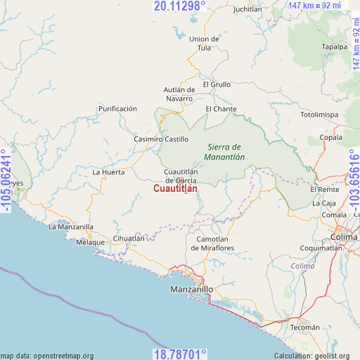
Cuautitlán GPS coordinates[2]
19° 27' 4.86" North, 104° 21' 33.408" West
| Map corner | latitude | longitude |
|---|---|---|
| Upper-left | 20.11298°, | -105.06241° |
| Center: | 19.45135°, | -104.35928° |
| Lower-right: | 18.78701°, | -103.65616° |
| Map W x H: | 147.4×147.4 km | = 91.6×91.6mi |
| max Lat: | 32.7° ⇑55% North |
| Cuautitlán: | 19.45135° |
| min Lat: | ⇓45% South 14.53588° |
| min Long | Cuautitlán | max Long |
| -117.105° | -104.35928° | -86.73105° |
| W 9.3%⇐ | ⇒90.7% E |
Elevation
Elevation of Cuautitlán is 604 m = 1982 ft, and this is 649.7 m = 2132 ft below average elevation for this country.
| Max E: |
3497 m = 11473 ft | 66.6% |
| Avg. | 1253.7 m = 4113 ft | |
| Cuautitlán | 604 m = 1982 ft | |
Min E: |
-1 m = -3 ft | 33.4% |
See also: Mexico elevation on elevation.city.
Geographical zone
Cuautitlán is located in North Torrid zone (between Equator and Tropic of Cancer). Distance of this Northern Tropic circle is 443.1 km =275.3 mi to North.| Distance of | km | miles | from Cuautitlán |
|---|---|---|---|
| North Pole | 7844.3 | 4874.2 | to North |
| Arctic Circle | 5238.4 | 3255 | to North |
| Tropic Cancer | 443.1 | 275.3 | to North |
| Equator | 2162.8 | 1343.9 | to South |


Nearby cities:
15 places around Cuautitlán: (largest is in red/bold)
• Ahuacapán
25.5 km =15.8 mi,  7°
7°
• Ayotitlán
18.5 km =11.5 mi,  83°
83°
• Cedros
22.5 km =14 mi,  145°
145°
• Chacala
15.9 km =9.9 mi, 149°
• Coyamel (El Coyame)
17.9 km =11.1 mi,  286°
286°
• Cuzalapa
6.9 km =4.3 mi,  41°
41°
• El Chico
14.2 km =8.8 mi, 148°
• El Chico
24.3 km =15.1 mi,  301°
301°
• La Resolana
18.8 km =11.7 mi,  335°
335°
• Lo Arado
26.4 km =16.4 mi,  315°
315°
• Piedra Pesada
16.5 km =10.3 mi,  311°
311°
• Tecomates
17.2 km =10.7 mi, 309°
• Telcruz
24.6 km =15.3 mi, 83°
• Tequesquitlán
18.3 km =11.4 mi,  247°
247°
• Zapotillo
22.1 km =13.7 mi, 337°
Sources, notices
• [Note1] Compared only with cities in Mexico existing in our database
• [Src1] Map data: © OpenStreetMap contributors (CC-BY-SA)
• [Src2] Other city data from geonames.org with taken over terms of usage.
• [Src3] Geographical zone / Annual Mean Temperature by Robert A. Rohde @ Wikipedia
