Villamar geodata
Villamar (Michoacán) is a seat of a second-order administrative division; located in Mexico in America/Mexico_City (GMT-6) time zone. With population of 3,095 people, there are 2911 cities with bigger population in this country. Compared to other cities in Mexico, 57.4% of cities are located further ↓South; 84.5% of cities are located further →East and 52.7% of cities have lower elevation than Villamar. Note1


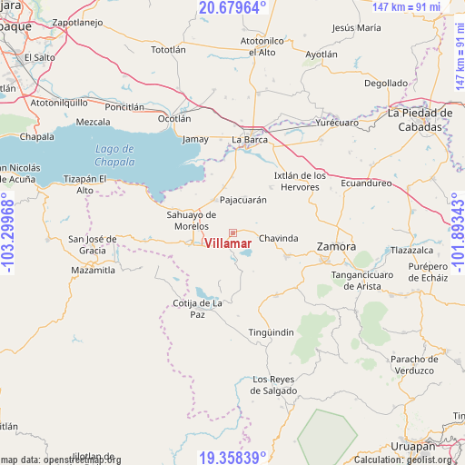
Villamar GPS coordinates[2]
20° 1' 13.44" North, 102° 35' 47.58" West
| Map corner | latitude | longitude |
|---|---|---|
| Upper-left | 20.67964°, | -103.29968° |
| Center: | 20.0204°, | -102.59655° |
| Lower-right: | 19.35839°, | -101.89343° |
| Map W x H: | 146.9×146.9 km | = 91.3×91.3mi |
| max Lat: | 32.7° ⇑42.6% North |
| Villamar: | 20.0204° |
| min Lat: | ⇓57.4% South 14.53588° |
| min Long | Villamar | max Long |
| -117.105° | -102.59655° | -86.73105° |
| W 15.5%⇐ | ⇒84.5% E |
Elevation
Elevation of Villamar is 1536 m = 5039 ft, and this is 282.3 m = 926 ft above average elevation for this country.
| Max E: |
3497 m = 11473 ft | 47.3% |
| Villamar | 1536 m 5039 ft | |
| Avg. | 1253.7 m = 4113 ft | |
Min E: |
-1 m = -3 ft | 52.7% |
See also: Mexico elevation on elevation.city.
Geographical zone
Villamar is located in North Torrid zone (between Equator and Tropic of Cancer). Distance of this Northern Tropic circle is 379.9 km =236.1 mi to North.| Distance of | km | miles | from Villamar |
|---|---|---|---|
| North Pole | 7781 | 4834.9 | to North |
| Arctic Circle | 5175.1 | 3215.7 | to North |
| Tropic Cancer | 379.9 | 236.1 | to North |
| Equator | 2226.1 | 1383.2 | to South |


Nearby cities:
15 places around Villamar: (largest is in red/bold)
• Cerrito Colorado
7.3 km =4.5 mi,  101°
101°
• Cerrito de Cotijarán
4.9 km =3 mi,  258°
258°
• El Paracho
12.4 km =7.7 mi,  38°
38°
• El Platanal
5 km =3.1 mi,  22°
22°
• Emiliano Zapata
3.6 km =2.2 mi,  213°
213°
• Fraccionamiento San Miguel
11 km =6.8 mi,  300°
300°
• Francisco Sarabia (Cerrito Pelón)
11 km =6.8 mi,  276°
276°
• La Cuestita
12.1 km =7.5 mi,  65°
65°
• Las Zarquillas
8 km =5 mi, 69°
• Los Remedios
9.9 km =6.2 mi,  241°
241°
• Pajacuarán
11.4 km =7.1 mi, 16°
• Pueblo Viejo
11.8 km =7.3 mi,  354°
354°
• San Antonio Guaracha
9.3 km =5.8 mi,  152°
152°
• San Martín Totolán
9.6 km =6 mi,  245°
245°
• Venustiano Carranza
12.2 km =7.6 mi,  330°
330°
Sources, notices
• [Note1] Compared only with cities in Mexico existing in our database
• [Src1] Map data: © OpenStreetMap contributors (CC-BY-SA)
• [Src2] Other city data from geonames.org with taken over terms of usage.
• [Src3] Geographical zone / Annual Mean Temperature by Robert A. Rohde @ Wikipedia
