San Antonio Guaracha geodata
San Antonio Guaracha (State of Mexico) is a populated place; located in Mexico in America/Mexico_City (GMT-6) time zone. With population of 1,608 people, there are 5383 cities with bigger population in this country. Compared to other cities in Mexico, 55.9% of cities are located further ↓South; 84.3% of cities are located further →East and 55.7% of cities have lower elevation than San Antonio Guaracha. Note1
Current local time in San Antonio Guaracha:
12:54 AM, WednesdayDifference from your time zone: hours


San Antonio Guaracha GPS coordinates[2]
19° 56' 45.312" North, 102° 33' 21.24" West
| Map corner | latitude | longitude |
|---|---|---|
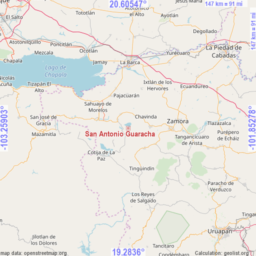
| Upper-left | 20.60547°, | -103.25903° |
| Center: | 19.94592°, | -102.5559° |
| Lower-right: | 19.2836°, | -101.85278° |
| Map W x H: | 147×147 km | = 91.3×91.3mi |
| max Lat: | 32.7° ⇑44.1% North |
| San Antonio Guaracha: | 19.94592° |
| min Lat: | ⇓55.9% South 14.53588° |
| min Long | San Antonio Gua | max Long |
| -117.105° | -102.5559° | -86.73105° |
| W 15.7%⇐ | ⇒84.3% E |
Elevation
Elevation of San Antonio Guaracha is 1607 m = 5272 ft, and this is 353.3 m = 1159 ft above average elevation for this country.
| Max E: |
3497 m = 11473 ft | 44.3% |
| San Antonio Guaracha | 1607 m 5272 ft | |
| Avg. | 1253.7 m = 4113 ft | |
Min E: |
-1 m = -3 ft | 55.7% |
See also: Mexico elevation on elevation.city.
Geographical zone
San Antonio Guaracha is located in North Torrid zone (between Equator and Tropic of Cancer). Distance of this Northern Tropic circle is 388.1 km =241.2 mi to North.| Distance of | km | miles | from San Antonio Guaracha |
|---|---|---|---|
| North Pole | 7789.3 | 4840 | to North |
| Arctic Circle | 5183.4 | 3220.8 | to North |
| Tropic Cancer | 388.1 | 241.2 | to North |
| Equator | 2217.8 | 1378.1 | to South |


Nearby cities:
15 places around San Antonio Guaracha: (largest is in red/bold)
• Cerrito Colorado
7.4 km =4.6 mi,  22°
22°
• Cerrito de Cotijarán
11.6 km =7.2 mi,  308°
308°
• Chavinda
12 km =7.5 mi,  56°
56°
• Churintzio
9.9 km =6.2 mi,  72°
72°
• El Guayabito
11.7 km =7.3 mi,  88°
88°
• El Platanal
13.1 km =8.1 mi,  349°
349°
• Emiliano Zapata
8.1 km =5 mi, 310°
• Las Estacas
4.4 km =2.7 mi,  151°
151°
• Las Zarquillas
11.5 km =7.1 mi, 16°
• Los Hucuares
8 km =5 mi,  130°
130°
• Los Remedios
13.4 km =8.3 mi,  285°
285°
• San Martín Totolán
13.7 km =8.5 mi, 288°
• Santiago Tangamandapio
12.6 km =7.8 mi, 85°
• Telonzo
11.5 km =7.1 mi,  75°
75°
• Villamar
9.3 km =5.8 mi,  332°
332°
Sources, notices
• [Note1] Compared only with cities in Mexico existing in our database
• [Src1] Map data: © OpenStreetMap contributors (CC-BY-SA)
• [Src2] Other city data from geonames.org with taken over terms of usage.
• [Src3] Geographical zone / Annual Mean Temperature by Robert A. Rohde @ Wikipedia
