El Platanal geodata
El Platanal (Michoacán) is a populated place; located in Mexico in America/Mexico_City (GMT-6) time zone. With population of 2,282 people, there are 3860 cities with bigger population in this country. Compared to other cities in Mexico, 58.4% of cities are located further ↓South; 84.4% of cities are located further →East and 52.3% of cities have lower elevation than El Platanal. Note1


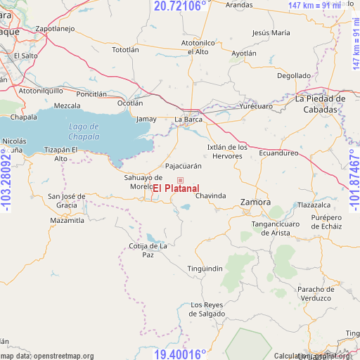
El Platanal GPS coordinates[2]
20° 3' 43.2" North, 102° 34' 40.044" West
| Map corner | latitude | longitude |
|---|---|---|
| Upper-left | 20.72106°, | -103.28092° |
| Center: | 20.062°, | -102.57779° |
| Lower-right: | 19.40016°, | -101.87467° |
| Map W x H: | 146.9×146.9 km | = 91.3×91.3mi |
| max Lat: | 32.7° ⇑41.6% North |
| El Platanal: | 20.062° |
| min Lat: | ⇓58.4% South 14.53588° |
| min Long | El Platanal | max Long |
| -117.105° | -102.57779° | -86.73105° |
| W 15.6%⇐ | ⇒84.4% E |
Elevation
Elevation of El Platanal is 1530 m = 5020 ft, and this is 276.3 m = 906 ft above average elevation for this country.
| Max E: |
3497 m = 11473 ft | 47.7% |
| El Platanal | 1530 m 5020 ft | |
| Avg. | 1253.7 m = 4113 ft | |
Min E: |
-1 m = -3 ft | 52.3% |
See also: Mexico elevation on elevation.city.
Geographical zone
El Platanal is located in North Torrid zone (between Equator and Tropic of Cancer). Distance of this Northern Tropic circle is 375.2 km =233.1 mi to North.| Distance of | km | miles | from El Platanal |
|---|---|---|---|
| North Pole | 7776.4 | 4832 | to North |
| Arctic Circle | 5170.5 | 3212.8 | to North |
| Tropic Cancer | 375.2 | 233.1 | to North |
| Equator | 2230.7 | 1386.1 | to South |


Nearby cities:
15 places around El Platanal: (largest is in red/bold)
• Cerrito Colorado
8 km =5 mi,  139°
139°
• Cerrito de Cotijarán
8.8 km =5.5 mi,  230°
230°
• El Fortín
13.3 km =8.3 mi,  349°
349°
• El Paracho
7.7 km =4.8 mi,  48°
48°
• Emiliano Zapata
8.6 km =5.3 mi,  207°
207°
• Fraccionamiento San Miguel
11.4 km =7.1 mi,  275°
275°
• La Cuestita
9.1 km =5.7 mi,  87°
87°
• Las Zarquillas
5.8 km =3.6 mi,  108°
108°
• Morelos
10.8 km =6.7 mi,  334°
334°
• Pajacuarán
6.5 km =4 mi,  10°
10°
• Pueblo Viejo
7.8 km =4.8 mi,  336°
336°
• San Antonio Guaracha
13.1 km =8.1 mi,  169°
169°
• Tecomatán
10.4 km =6.5 mi,  55°
55°
• Venustiano Carranza
9.9 km =6.2 mi,  306°
306°
• Villamar
5 km =3.1 mi,  202°
202°
Sources, notices
• [Note1] Compared only with cities in Mexico existing in our database
• [Src1] Map data: © OpenStreetMap contributors (CC-BY-SA)
• [Src2] Other city data from geonames.org with taken over terms of usage.
• [Src3] Geographical zone / Annual Mean Temperature by Robert A. Rohde @ Wikipedia
