Agua Gorda geodata
Agua Gorda (Zacatecas) is a populated place; located in Mexico in America/Mexico_City (GMT-6) time zone. With population of 1,023 people, there are 8510 cities with bigger population in this country. Compared to other cities in Mexico, 84.7% of cities are located further ↓South; 80.5% of cities are located further →East and 78.6% of cities have lower elevation than Agua Gorda. Note1


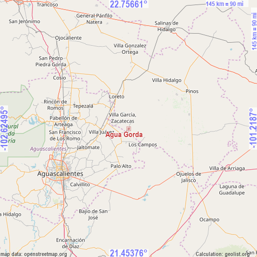
Agua Gorda GPS coordinates[2]
22° 6' 24.084" North, 101° 55' 18.552" West
| Map corner | latitude | longitude |
|---|---|---|
| Upper-left | 22.75661°, | -102.62495° |
| Center: | 22.10669°, | -101.92182° |
| Lower-right: | 21.45376°, | -101.2187° |
| Map W x H: | 144.9×144.9 km | = 90×90mi |
| max Lat: | 32.7° ⇑15.3% North |
| Agua Gorda: | 22.10669° |
| min Lat: | ⇓84.7% South 14.53588° |
| min Long | Agua Gorda | max Long |
| -117.105° | -101.92182° | -86.73105° |
| W 19.5%⇐ | ⇒80.5% E |
Elevation
Elevation of Agua Gorda is 2102 m = 6896 ft, and this is 848.3 m = 2783 ft above average elevation for this country.
| Max E: |
3497 m = 11473 ft | 21.4% |
| Agua Gorda | 2102 m 6896 ft | |
| Avg. | 1253.7 m = 4113 ft | |
Min E: |
-1 m = -3 ft | 78.6% |
See also: Mexico elevation on elevation.city.
Geographical zone
Agua Gorda is located in North Torrid zone (between Equator and Tropic of Cancer). Distance of this Northern Tropic circle is 147.9 km =91.9 mi to North.| Distance of | km | miles | from Agua Gorda |
|---|---|---|---|
| North Pole | 7549 | 4690.7 | to North |
| Arctic Circle | 4943.1 | 3071.5 | to North |
| Tropic Cancer | 147.9 | 91.9 | to North |
| Equator | 2458 | 1527.3 | to South |


Nearby cities:
15 places around Agua Gorda: (largest is in red/bold)
• Agua Gordita
5.7 km =3.5 mi,  300°
300°
• Ciénega Grande
14 km =8.7 mi,  314°
314°
• El Copetillo
9.2 km =5.7 mi, 296°
• El Novillo
12.6 km =7.8 mi,  220°
220°
• Emilio Carranza
12.2 km =7.6 mi,  46°
46°
• Francisco Villa
5.3 km =3.3 mi,  246°
246°
• Granadas
6.1 km =3.8 mi,  96°
96°
• La Luz
14.1 km =8.8 mi,  212°
212°
• La Montesa
10.4 km =6.5 mi,  116°
116°
• Las Negritas
13.8 km =8.6 mi,  161°
161°
• Los Campos
12 km =7.5 mi,  137°
137°
• Lázaro Cárdenas
13 km =8.1 mi, 303°
• Pilotos
8.6 km =5.3 mi, 206°
• Tierritas Blancas
1.5 km =0.9 mi,  16°
16°
• Villa García
7 km =4.3 mi,  330°
330°
Sources, notices
• [Note1] Compared only with cities in Mexico existing in our database
• [Src1] Map data: © OpenStreetMap contributors (CC-BY-SA)
• [Src2] Other city data from geonames.org with taken over terms of usage.
• [Src3] Geographical zone / Annual Mean Temperature by Robert A. Rohde @ Wikipedia
