Verdía geodata
Verdía (Jalisco) is a populated place; located in Mexico in America/Mexico_City (GMT-6) time zone. With population of 775 people, there are 11274 cities with bigger population in this country. Compared to other cities in Mexico, 60.4% of cities are located further ↓South; 88.3% of cities are located further →East and 51.8% of cities have higher elevation than Verdía. Note1


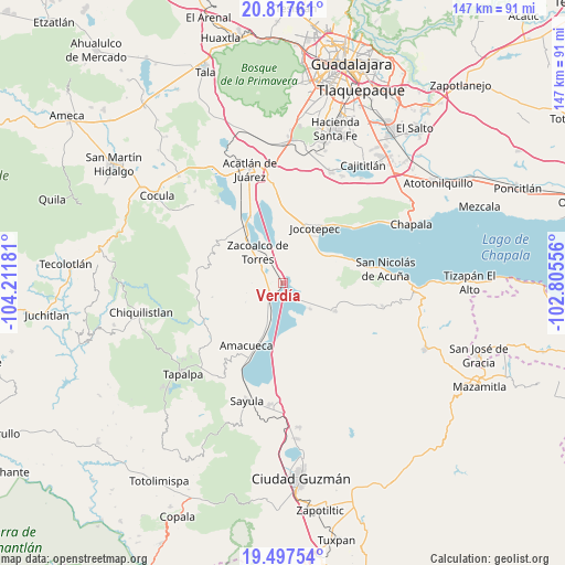
Verdía GPS coordinates[2]
20° 9' 32.292" North, 103° 30' 31.248" West
| Map corner | latitude | longitude |
|---|---|---|
| Upper-left | 20.81761°, | -104.21181° |
| Center: | 20.15897°, | -103.50868° |
| Lower-right: | 19.49754°, | -102.80556° |
| Map W x H: | 146.8×146.8 km | = 91.2×91.2mi |
| max Lat: | 32.7° ⇑39.6% North |
| Verdía: | 20.15897° |
| min Lat: | ⇓60.4% South 14.53588° |
| min Long | Verdía | max Long |
| -117.105° | -103.50868° | -86.73105° |
| W 11.7%⇐ | ⇒88.3% E |
Elevation
Elevation of Verdía is 1350 m = 4429 ft, and this is 96.3 m = 316 ft above average elevation for this country.
| Max E: |
3497 m = 11473 ft | 51.8% |
| Verdía | 1350 m 4429 ft | |
| Avg. | 1253.7 m = 4113 ft | |
Min E: |
-1 m = -3 ft | 48.2% |
See also: Mexico elevation on elevation.city.
Geographical zone
Verdía is located in North Torrid zone (between Equator and Tropic of Cancer). Distance of this Northern Tropic circle is 364.5 km =226.5 mi to North.| Distance of | km | miles | from Verdía |
|---|---|---|---|
| North Pole | 7765.6 | 4825.3 | to North |
| Arctic Circle | 5159.7 | 3206.1 | to North |
| Tropic Cancer | 364.5 | 226.5 | to North |
| Equator | 2241.5 | 1392.8 | to South |


Nearby cities:
15 places around Verdía: (largest is in red/bold)
• Amacueca
19 km =11.8 mi,  209°
209°
• Atoyac
16.6 km =10.3 mi,  182°
182°
• Barranca de Santa Clara
18.7 km =11.6 mi,  305°
305°
• Benito Juárez
17 km =10.6 mi,  325°
325°
• Cacaluta
2.8 km =1.7 mi,  71°
71°
• Jocotepec
16.3 km =10.1 mi,  30°
30°
• Milpilla
11.4 km =7.1 mi,  101°
101°
• San Cristóbal Zapotitlán
16.2 km =10.1 mi,  63°
63°
• San José de Gracia
9.8 km =6.1 mi,  133°
133°
• San Marcos
18 km =11.2 mi,  351°
351°
• San Pedro Tesistán
12.4 km =7.7 mi,  52°
52°
• Techaluta de Montenegro
10.5 km =6.5 mi,  204°
204°
• Teocuitatlán de Corona
15.5 km =9.6 mi,  118°
118°
• Zacoalco de Torres
9.9 km =6.2 mi,  320°
320°
• Zapotitán de Hidalgo
18.9 km =11.7 mi,  9°
9°
Sources, notices
• [Note1] Compared only with cities in Mexico existing in our database
• [Src1] Map data: © OpenStreetMap contributors (CC-BY-SA)
• [Src2] Other city data from geonames.org with taken over terms of usage.
• [Src3] Geographical zone / Annual Mean Temperature by Robert A. Rohde @ Wikipedia
