Amacueca geodata
Amacueca (Jalisco) is a seat of a second-order administrative division; located in Mexico in America/Mexico_City (GMT-6) time zone. With population of 2,875 people, there are 3094 cities with bigger population in this country. Compared to other cities in Mexico, 57.2% of cities are located further ↓South; 88.7% of cities are located further →East and 50% of cities have lower elevation than Amacueca. Note1


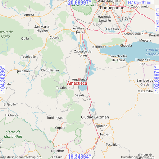
Amacueca GPS coordinates[2]
20° 0' 38.484" North, 103° 35' 59.388" West
| Map corner | latitude | longitude |
|---|---|---|
| Upper-left | 20.66997°, | -104.30296° |
| Center: | 20.01069°, | -103.59983° |
| Lower-right: | 19.34864°, | -102.89671° |
| Map W x H: | 146.9×146.9 km | = 91.3×91.3mi |
| max Lat: | 32.7° ⇑42.8% North |
| Amacueca: | 20.01069° |
| min Lat: | ⇓57.2% South 14.53588° |
| min Long | Amacueca | max Long |
| -117.105° | -103.59983° | -86.73105° |
| W 11.3%⇐ | ⇒88.7% E |
Elevation
Elevation of Amacueca is 1433 m = 4701 ft, and this is 179.3 m = 588 ft above average elevation for this country.
| Max E: |
3497 m = 11473 ft | 50% |
| Amacueca | 1433 m 4701 ft | |
| Avg. | 1253.7 m = 4113 ft | |
Min E: |
-1 m = -3 ft | 50% |
See also: Mexico elevation on elevation.city.
Geographical zone
Amacueca is located in North Torrid zone (between Equator and Tropic of Cancer). Distance of this Northern Tropic circle is 380.9 km =236.7 mi to North.| Distance of | km | miles | from Amacueca |
|---|---|---|---|
| North Pole | 7782.1 | 4835.6 | to North |
| Arctic Circle | 5176.2 | 3216.3 | to North |
| Tropic Cancer | 380.9 | 236.7 | to North |
| Equator | 2225 | 1382.6 | to South |


Nearby cities:
15 places around Amacueca: (largest is in red/bold)
• Atacco
17.6 km =10.9 mi,  237°
237°
• Atoyac
8.7 km =5.4 mi,  90°
90°
• Cuyacapan
9.3 km =5.8 mi,  121°
121°
• Ferrería de Tula
14.9 km =9.3 mi,  294°
294°
• Juanacatlán
9.4 km =5.8 mi, 285°
• Los Espinos
14.8 km =9.2 mi,  259°
259°
• San Antonio
12.4 km =7.7 mi,  246°
246°
• San José de Gracia
19.2 km =11.9 mi,  59°
59°
• Sayula
14.3 km =8.9 mi,  180°
180°
• Tapalpa
18.2 km =11.3 mi, 246°
• Techaluta de Montenegro
8.6 km =5.3 mi,  36°
36°
• Tepec
4.9 km =3 mi, 241°
• Unión de Guadalupe
19.2 km =11.9 mi,  125°
125°
• Usmajac
16.3 km =10.1 mi,  157°
157°
• Verdía
19 km =11.8 mi,  29°
29°
Sources, notices
• [Note1] Compared only with cities in Mexico existing in our database
• [Src1] Map data: © OpenStreetMap contributors (CC-BY-SA)
• [Src2] Other city data from geonames.org with taken over terms of usage.
• [Src3] Geographical zone / Annual Mean Temperature by Robert A. Rohde @ Wikipedia
