Jocotepec geodata
Jocotepec (Jalisco) is a seat of a second-order administrative division; located in Mexico in America/Mexico_City (GMT-6) time zone. With population of 18,852 people, there are 519 cities with bigger population in this country. Compared to other cities in Mexico, 63.2% of cities are located further ↓South; 88% of cities are located further →East and 53.2% of cities have lower elevation than Jocotepec. Note1


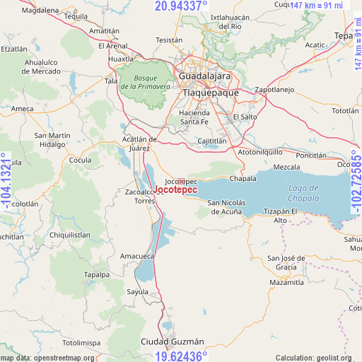
Jocotepec GPS coordinates[2]
20° 17' 6.972" North, 103° 25' 44.292" West
| Map corner | latitude | longitude |
|---|---|---|
| Upper-left | 20.94337°, | -104.1321° |
| Center: | 20.28527°, | -103.42897° |
| Lower-right: | 19.62436°, | -102.72585° |
| Map W x H: | 146.7×146.7 km | = 91.2×91.2mi |
| max Lat: | 32.7° ⇑36.8% North |
| Jocotepec: | 20.28527° |
| min Lat: | ⇓63.2% South 14.53588° |
| min Long | Jocotepec | max Long |
| -117.105° | -103.42897° | -86.73105° |
| W 12%⇐ | ⇒88% E |
Elevation
Elevation of Jocotepec is 1544 m = 5066 ft, and this is 290.3 m = 952 ft above average elevation for this country.
| Max E: |
3497 m = 11473 ft | 46.8% |
| Jocotepec | 1544 m 5066 ft | |
| Avg. | 1253.7 m = 4113 ft | |
Min E: |
-1 m = -3 ft | 53.2% |
See also: Mexico elevation on elevation.city.
Geographical zone
Jocotepec is located in North Torrid zone (between Equator and Tropic of Cancer). Distance of this Northern Tropic circle is 350.4 km =217.7 mi to North.| Distance of | km | miles | from Jocotepec |
|---|---|---|---|
| North Pole | 7751.6 | 4816.6 | to North |
| Arctic Circle | 5145.7 | 3197.4 | to North |
| Tropic Cancer | 350.4 | 217.7 | to North |
| Equator | 2255.5 | 1401.5 | to South |


Nearby cities:
15 places around Jocotepec: (largest is in red/bold)
• Cacaluta
14.4 km =8.9 mi,  203°
203°
• El Molino
16 km =9.9 mi,  315°
315°
• Huejotitán
9.9 km =6.2 mi, 321°
• Las Trojes
11.8 km =7.3 mi,  62°
62°
• Potrerillos
8 km =5 mi,  42°
42°
• San Cristóbal Zapotitlán
9.2 km =5.7 mi,  137°
137°
• San Juan Cosalá
9.2 km =5.7 mi,  88°
88°
• San Lucas Evangelista
15.4 km =9.6 mi,  27°
27°
• San Luis Soyatlán
16 km =9.9 mi,  127°
127°
• San Marcos
11.6 km =7.2 mi,  288°
288°
• San Miguel Cuyutlán
15.1 km =9.4 mi,  15°
15°
• San Pedro Tesistán
6.7 km =4.2 mi,  167°
167°
• Verdía
16.3 km =10.1 mi,  210°
210°
• Zacoalco de Torres
15.9 km =9.9 mi,  246°
246°
• Zapotitán de Hidalgo
6.9 km =4.3 mi,  311°
311°
Sources, notices
• [Note1] Compared only with cities in Mexico existing in our database
• [Src1] Map data: © OpenStreetMap contributors (CC-BY-SA)
• [Src2] Other city data from geonames.org with taken over terms of usage.
• [Src3] Geographical zone / Annual Mean Temperature by Robert A. Rohde @ Wikipedia
