Milpilla geodata
Milpilla (Jalisco) is a populated place; located in Mexico in America/Mexico_City (GMT-6) time zone. With population of 530 people, there are 15970 cities with bigger population in this country. Compared to other cities in Mexico, 60% of cities are located further ↓South; 87.8% of cities are located further →East and 51.4% of cities have higher elevation than Milpilla. Note1


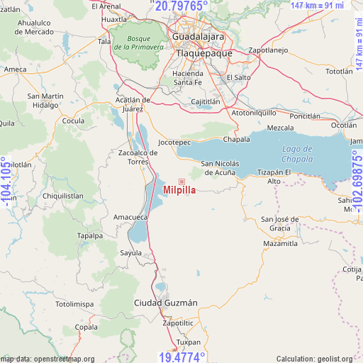
Milpilla GPS coordinates[2]
20° 8' 20.112" North, 103° 24' 6.732" West
| Map corner | latitude | longitude |
|---|---|---|
| Upper-left | 20.79765°, | -104.105° |
| Center: | 20.13892°, | -103.40187° |
| Lower-right: | 19.4774°, | -102.69875° |
| Map W x H: | 146.8×146.8 km | = 91.2×91.2mi |
| max Lat: | 32.7° ⇑40% North |
| Milpilla: | 20.13892° |
| min Lat: | ⇓60% South 14.53588° |
| min Long | Milpilla | max Long |
| -117.105° | -103.40187° | -86.73105° |
| W 12.2%⇐ | ⇒87.8% E |
Elevation
Elevation of Milpilla is 1363 m = 4472 ft, and this is 109.3 m = 359 ft above average elevation for this country.
| Max E: |
3497 m = 11473 ft | 51.4% |
| Milpilla | 1363 m 4472 ft | |
| Avg. | 1253.7 m = 4113 ft | |
Min E: |
-1 m = -3 ft | 48.6% |
See also: Mexico elevation on elevation.city.
Geographical zone
Milpilla is located in North Torrid zone (between Equator and Tropic of Cancer). Distance of this Northern Tropic circle is 366.7 km =227.9 mi to North.| Distance of | km | miles | from Milpilla |
|---|---|---|---|
| North Pole | 7767.8 | 4826.7 | to North |
| Arctic Circle | 5161.9 | 3207.5 | to North |
| Tropic Cancer | 366.7 | 227.9 | to North |
| Equator | 2239.2 | 1391.4 | to South |


Nearby cities:
15 places around Milpilla: (largest is in red/bold)
• Atoyac
18.7 km =11.6 mi,  219°
219°
• Cacaluta
9.1 km =5.7 mi,  289°
289°
• Citala
15.1 km =9.4 mi,  104°
104°
• Jocotepec
16.5 km =10.3 mi,  350°
350°
• Potrerillos
22.3 km =13.9 mi,  6°
6°
• San Cristóbal Zapotitlán
10.1 km =6.3 mi,  19°
19°
• San José de Gracia
6.1 km =3.8 mi, 221°
• San Juan Cosalá
17.7 km =11 mi, 20°
• San Luis Soyatlán
11.9 km =7.4 mi,  56°
56°
• San Pedro Tesistán
9.9 km =6.2 mi, 352°
• Techaluta de Montenegro
17.2 km =10.7 mi,  244°
244°
• Teocuitatlán de Corona
5.8 km =3.6 mi,  154°
154°
• Tepeguaje
20 km =12.4 mi,  79°
79°
• Verdía
11.4 km =7.1 mi,  281°
281°
• Zacoalco de Torres
20 km =12.4 mi,  299°
299°
Sources, notices
• [Note1] Compared only with cities in Mexico existing in our database
• [Src1] Map data: © OpenStreetMap contributors (CC-BY-SA)
• [Src2] Other city data from geonames.org with taken over terms of usage.
• [Src3] Geographical zone / Annual Mean Temperature by Robert A. Rohde @ Wikipedia
