Uzeta geodata
Uzeta (Nayarit) is a populated place; located in Mexico in America/Mazatlan (GMT-7) time zone. With population of 1,704 people, there are 5100 cities with bigger population in this country. Compared to other cities in Mexico, 78.1% of cities are located further ↓South; 91.2% of cities are located further →East and 63.6% of cities have higher elevation than Uzeta. Note1


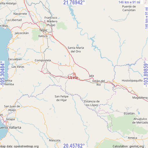
Uzeta GPS coordinates[2]
21° 6' 53.892" North, 104° 36' 6.156" West
| Map corner | latitude | longitude |
|---|---|---|
| Upper-left | 21.76942°, | -105.30484° |
| Center: | 21.11497°, | -104.60171° |
| Lower-right: | 20.45762°, | -103.89859° |
| Map W x H: | 145.9×145.9 km | = 90.7×90.7mi |
| max Lat: | 32.7° ⇑21.9% North |
| Uzeta: | 21.11497° |
| min Lat: | ⇓78.1% South 14.53588° |
| min Long | Uzeta | max Long |
| -117.105° | -104.60171° | -86.73105° |
| W 8.8%⇐ | ⇒91.2% E |
Elevation
Elevation of Uzeta is 775 m = 2543 ft, and this is 478.7 m = 1571 ft below average elevation for this country.
| Max E: |
3497 m = 11473 ft | 63.6% |
| Avg. | 1253.7 m = 4113 ft | |
| Uzeta | 775 m = 2543 ft | |
Min E: |
-1 m = -3 ft | 36.4% |
See also: Mexico elevation on elevation.city.
Geographical zone
Uzeta is located in North Torrid zone (between Equator and Tropic of Cancer). Distance of this Northern Tropic circle is 258.2 km =160.4 mi to North.| Distance of | km | miles | from Uzeta |
|---|---|---|---|
| North Pole | 7659.3 | 4759.3 | to North |
| Arctic Circle | 5053.4 | 3140 | to North |
| Tropic Cancer | 258.2 | 160.4 | to North |
| Equator | 2347.8 | 1458.9 | to South |


Nearby cities:
15 places around Uzeta: (largest is in red/bold)
• Ahuacatlán
14 km =8.7 mi,  119°
119°
• Chapalilla
9 km =5.6 mi,  335°
335°
• Cuastecomate
17.6 km =10.9 mi,  243°
243°
• Heriberto Jara
11.2 km =7 mi,  128°
128°
• Jala
17.1 km =10.6 mi,  93°
93°
• Jomulco
18.5 km =11.5 mi, 93°
• Marquezado
5.2 km =3.2 mi,  144°
144°
• San Pedro Lagunillas
19.4 km =12.1 mi,  306°
306°
• Santa Cruz de Camotlán
18.9 km =11.7 mi,  201°
201°
• Santa Isabel
5.8 km =3.6 mi, 336°
• Tequepexpan
11.7 km =7.3 mi,  16°
16°
• Tequilita
20.6 km =12.8 mi,  261°
261°
• Tetitlán
2.2 km =1.4 mi,  316°
316°
• Valle Verde
2.1 km =1.3 mi,  287°
287°
• Zapotanito
21.2 km =13.2 mi,  357°
357°
Sources, notices
• [Note1] Compared only with cities in Mexico existing in our database
• [Src1] Map data: © OpenStreetMap contributors (CC-BY-SA)
• [Src2] Other city data from geonames.org with taken over terms of usage.
• [Src3] Geographical zone / Annual Mean Temperature by Robert A. Rohde @ Wikipedia
