Ahuacatlán geodata
Ahuacatlán (Nayarit) is a seat of a second-order administrative division; located in Mexico in America/Mazatlan (GMT-7) time zone. With population of 6,754 people, there are 1385 cities with bigger population in this country. Compared to other cities in Mexico, 77.3% of cities are located further ↓South; 90.9% of cities are located further →East and 60.1% of cities have higher elevation than Ahuacatlán. Note1


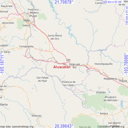
Ahuacatlán GPS coordinates[2]
21° 3' 14.58" North, 104° 29' 2.328" West
| Map corner | latitude | longitude |
|---|---|---|
| Upper-left | 21.70878°, | -105.18711° |
| Center: | 21.05405°, | -104.48398° |
| Lower-right: | 20.39643°, | -103.78086° |
| Map W x H: | 145.9×145.9 km | = 90.7×90.7mi |
| max Lat: | 32.7° ⇑22.7% North |
| Ahuacatlán: | 21.05405° |
| min Lat: | ⇓77.3% South 14.53588° |
| min Long | Ahuacatlán | max Long |
| -117.105° | -104.48398° | -86.73105° |
| W 9.1%⇐ | ⇒90.9% E |
Elevation
Elevation of Ahuacatlán is 999 m = 3278 ft, and this is 254.7 m = 836 ft below average elevation for this country.
| Max E: |
3497 m = 11473 ft | 60.1% |
| Avg. | 1253.7 m = 4113 ft | |
| Ahuacatlán | 999 m = 3278 ft | |
Min E: |
-1 m = -3 ft | 39.9% |
See also: Mexico elevation on elevation.city.
Geographical zone
Ahuacatlán is located in North Torrid zone (between Equator and Tropic of Cancer). Distance of this Northern Tropic circle is 264.9 km =164.6 mi to North.| Distance of | km | miles | from Ahuacatlán |
|---|---|---|---|
| North Pole | 7666.1 | 4763.5 | to North |
| Arctic Circle | 5060.2 | 3144.3 | to North |
| Tropic Cancer | 264.9 | 164.6 | to North |
| Equator | 2341 | 1454.6 | to South |


Nearby cities:
15 places around Ahuacatlán: (largest is in red/bold)
• Francisco I. Madero (La Bolsa)
16.8 km =10.4 mi,  75°
75°
• Heriberto Jara
3.5 km =2.2 mi,  266°
266°
• Ixtlán del Río
11.8 km =7.3 mi,  98°
98°
• Jala
7.4 km =4.6 mi,  40°
40°
• Jomulco
8.4 km =5.2 mi,  48°
48°
• La Cofradía
17.8 km =11.1 mi,  70°
70°
• Los Aguajes
14.7 km =9.1 mi, 66°
• Los Mezquites
16.7 km =10.4 mi,  201°
201°
• Marquezado
9.5 km =5.9 mi,  285°
285°
• Méxpan
7.5 km =4.7 mi,  105°
105°
• Rosa Blanca
15.2 km =9.4 mi,  59°
59°
• San Miguel de Buenavista
15.6 km =9.7 mi, 70°
• Tetitlán
16 km =9.9 mi,  301°
301°
• Uzeta
14 km =8.7 mi, 299°
• Valle Verde
16 km =9.9 mi, 297°
Sources, notices
• [Note1] Compared only with cities in Mexico existing in our database
• [Src1] Map data: © OpenStreetMap contributors (CC-BY-SA)
• [Src2] Other city data from geonames.org with taken over terms of usage.
• [Src3] Geographical zone / Annual Mean Temperature by Robert A. Rohde @ Wikipedia
