Jala geodata
Jala (Nayarit) is a seat of a second-order administrative division; located in Mexico in America/Mazatlan (GMT-7) time zone. With population of 5,586 people, there are 1670 cities with bigger population in this country. Compared to other cities in Mexico, 77.9% of cities are located further ↓South; 90.8% of cities are located further →East and 58.7% of cities have higher elevation than Jala. Note1


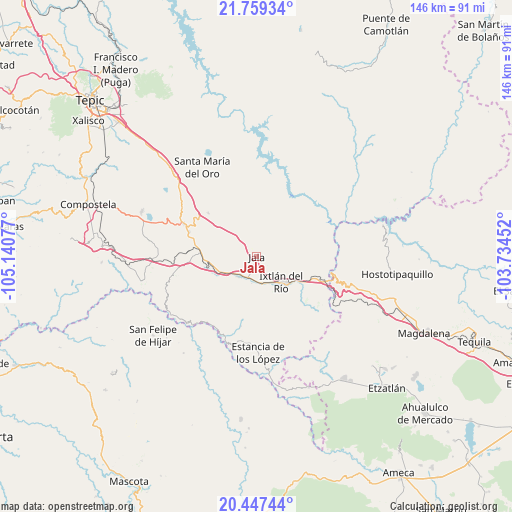
Jala GPS coordinates[2]
21° 6' 17.424" North, 104° 26' 15.504" West
| Map corner | latitude | longitude |
|---|---|---|
| Upper-left | 21.75934°, | -105.14077° |
| Center: | 21.10484°, | -104.43764° |
| Lower-right: | 20.44744°, | -103.73452° |
| Map W x H: | 145.9×145.9 km | = 90.7×90.7mi |
| max Lat: | 32.7° ⇑22.1% North |
| Jala: | 21.10484° |
| min Lat: | ⇓77.9% South 14.53588° |
| min Long | Jala | max Long |
| -117.105° | -104.43764° | -86.73105° |
| W 9.2%⇐ | ⇒90.8% E |
Elevation
Elevation of Jala is 1070 m = 3510 ft, and this is 183.7 m = 603 ft below average elevation for this country.
| Max E: |
3497 m = 11473 ft | 58.7% |
| Avg. | 1253.7 m = 4113 ft | |
| Jala | 1070 m = 3510 ft | |
Min E: |
-1 m = -3 ft | 41.3% |
See also: Mexico elevation on elevation.city.
Geographical zone
Jala is located in North Torrid zone (between Equator and Tropic of Cancer). Distance of this Northern Tropic circle is 259.3 km =161.1 mi to North.| Distance of | km | miles | from Jala |
|---|---|---|---|
| North Pole | 7660.4 | 4760 | to North |
| Arctic Circle | 5054.5 | 3140.7 | to North |
| Tropic Cancer | 259.3 | 161.1 | to North |
| Equator | 2346.6 | 1458.1 | to South |


Nearby cities:
15 places around Jala: (largest is in red/bold)
• Ahuacatlán
7.4 km =4.6 mi,  220°
220°
• Francisco I. Madero (La Bolsa)
11.5 km =7.1 mi,  96°
96°
• Heriberto Jara
10.2 km =6.3 mi,  234°
234°
• Ixtlán del Río
10.1 km =6.3 mi,  136°
136°
• Jomulco
1.4 km =0.9 mi,  93°
93°
• La Cofradía
12.1 km =7.5 mi, 89°
• Los Aguajes
8.6 km =5.3 mi, 88°
• Marquezado
14.3 km =8.9 mi,  257°
257°
• Méxpan
8 km =5 mi,  162°
162°
• Rosa Blanca
8.5 km =5.3 mi,  75°
75°
• San Miguel de Buenavista
9.9 km =6.2 mi, 92°
• Tequepexpan
18.4 km =11.4 mi,  312°
312°
• Tetitlán
18.7 km =11.6 mi,  278°
278°
• Uzeta
17.1 km =10.6 mi,  273°
273°
• Valle Verde
19.1 km =11.9 mi, 275°
Sources, notices
• [Note1] Compared only with cities in Mexico existing in our database
• [Src1] Map data: © OpenStreetMap contributors (CC-BY-SA)
• [Src2] Other city data from geonames.org with taken over terms of usage.
• [Src3] Geographical zone / Annual Mean Temperature by Robert A. Rohde @ Wikipedia
