Zapotanito geodata
Zapotanito (Nayarit) is a populated place; located in Mexico in America/Mazatlan (GMT-7) time zone. With population of 1,116 people, there are 7786 cities with bigger population in this country. Compared to other cities in Mexico, 80.1% of cities are located further ↓South; 91.2% of cities are located further →East and 55.8% of cities have higher elevation than Zapotanito. Note1


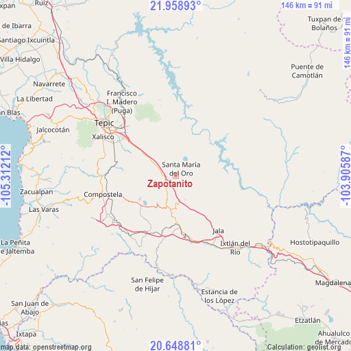
Zapotanito GPS coordinates[2]
21° 18' 19.188" North, 104° 36' 32.364" West
| Map corner | latitude | longitude |
|---|---|---|
| Upper-left | 21.95893°, | -105.31212° |
| Center: | 21.30533°, | -104.60899° |
| Lower-right: | 20.64881°, | -103.90587° |
| Map W x H: | 145.7×145.7 km | = 90.5×90.5mi |
| max Lat: | 32.7° ⇑19.9% North |
| Zapotanito: | 21.30533° |
| min Lat: | ⇓80.1% South 14.53588° |
| min Long | Zapotanito | max Long |
| -117.105° | -104.60899° | -86.73105° |
| W 8.8%⇐ | ⇒91.2% E |
Elevation
Elevation of Zapotanito is 1168 m = 3832 ft, and this is 85.7 m = 281 ft below average elevation for this country.
| Max E: |
3497 m = 11473 ft | 55.8% |
| Avg. | 1253.7 m = 4113 ft | |
| Zapotanito | 1168 m = 3832 ft | |
Min E: |
-1 m = -3 ft | 44.2% |
See also: Mexico elevation on elevation.city.
Geographical zone
Zapotanito is located in North Torrid zone (between Equator and Tropic of Cancer). Distance of this Northern Tropic circle is 237 km =147.3 mi to North.| Distance of | km | miles | from Zapotanito |
|---|---|---|---|
| North Pole | 7638.1 | 4746.1 | to North |
| Arctic Circle | 5032.2 | 3126.9 | to North |
| Tropic Cancer | 237 | 147.3 | to North |
| Equator | 2368.9 | 1472 | to South |


Nearby cities:
15 places around Zapotanito: (largest is in red/bold)
• Cerro Blanco
8.2 km =5.1 mi,  351°
351°
• Chapalilla
13.3 km =8.3 mi,  192°
192°
• Cofradía de Acuitapilco
9.7 km =6 mi,  63°
63°
• El Buruato
13 km =8.1 mi,  25°
25°
• El Limón
6.6 km =4.1 mi,  330°
330°
• La Labor
13.7 km =8.5 mi,  303°
303°
• Mojarras
13.4 km =8.3 mi,  0°
0°
• San Leonel
10.8 km =6.7 mi, 297°
• San Pedro Lagunillas
17.7 km =11 mi,  237°
237°
• Santa Isabel
15.9 km =9.9 mi, 185°
• Santa María del Oro
3.9 km =2.4 mi,  35°
35°
• Tequepexpan
10.8 km =6.7 mi,  157°
157°
• Tetitlán
19.6 km =12.2 mi,  182°
182°
• Uzeta
21.2 km =13.2 mi, 177°
• Valle Verde
20.6 km =12.8 mi, 183°
Sources, notices
• [Note1] Compared only with cities in Mexico existing in our database
• [Src1] Map data: © OpenStreetMap contributors (CC-BY-SA)
• [Src2] Other city data from geonames.org with taken over terms of usage.
• [Src3] Geographical zone / Annual Mean Temperature by Robert A. Rohde @ Wikipedia
