San Pedro Lagunillas geodata
San Pedro Lagunillas (Nayarit) is a seat of a second-order administrative division; located in Mexico in America/Mazatlan (GMT-7) time zone. With population of 3,753 people, there are 2444 cities with bigger population in this country. Compared to other cities in Mexico, 79.3% of cities are located further ↓South; 91.5% of cities are located further →East and 52.9% of cities have higher elevation than San Pedro Lagunillas. Note1
Current local time in San Pedro Lagunillas:
05:48 AM, WednesdayDifference from your time zone: hours


San Pedro Lagunillas GPS coordinates[2]
21° 13' 9.12" North, 104° 45' 8.208" West
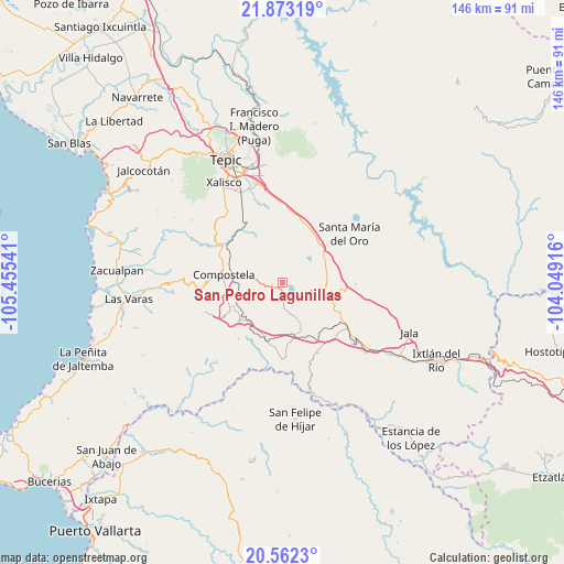
| Map corner | latitude | longitude |
|---|---|---|
| Upper-left | 21.87319°, | -105.45541° |
| Center: | 21.2192°, | -104.75228° |
| Lower-right: | 20.5623°, | -104.04916° |
| Map W x H: | 145.8×145.8 km | = 90.6×90.6mi |
| max Lat: | 32.7° ⇑20.7% North |
| San Pedro Lagunillas: | 21.2192° |
| min Lat: | ⇓79.3% South 14.53588° |
| min Long | San Pedro Lagun | max Long |
| -117.105° | -104.75228° | -86.73105° |
| W 8.5%⇐ | ⇒91.5% E |
Elevation
Elevation of San Pedro Lagunillas is 1293 m = 4242 ft, and this is 39.3 m = 129 ft above average elevation for this country.
| Max E: |
3497 m = 11473 ft | 52.9% |
| San Pedro Lagunillas | 1293 m 4242 ft | |
| Avg. | 1253.7 m = 4113 ft | |
Min E: |
-1 m = -3 ft | 47.1% |
See also: Mexico elevation on elevation.city.
Geographical zone
San Pedro Lagunillas is located in North Torrid zone (between Equator and Tropic of Cancer). Distance of this Northern Tropic circle is 246.6 km =153.2 mi to North.| Distance of | km | miles | from San Pedro Lagunillas |
|---|---|---|---|
| North Pole | 7647.7 | 4752.1 | to North |
| Arctic Circle | 5041.8 | 3132.8 | to North |
| Tropic Cancer | 246.6 | 153.2 | to North |
| Equator | 2359.4 | 1466.1 | to South |


Nearby cities:
15 places around San Pedro Lagunillas: (largest is in red/bold)
• Chapalilla
12.3 km =7.6 mi,  106°
106°
• Compostela
15.5 km =9.6 mi,  277°
277°
• Felipe Carrillo Puerto
14.8 km =9.2 mi,  229°
229°
• Juan Escutia (Borbollón)
13.2 km =8.2 mi,  244°
244°
• La Curva
17.9 km =11.1 mi,  330°
330°
• La Labor
17.4 km =10.8 mi,  11°
11°
• Miravalles
14.9 km =9.3 mi,  299°
299°
• San Leonel
15.4 km =9.6 mi,  19°
19°
• Santa Isabel
14.7 km =9.1 mi,  115°
115°
• Tequepexpan
18.9 km =11.7 mi,  91°
91°
• Tequilita
15.4 km =9.6 mi,  198°
198°
• Tetitlán
17.3 km =10.7 mi,  125°
125°
• Valle Verde
17.5 km =10.9 mi, 128°
• Zapotanito
17.7 km =11 mi,  57°
57°
• Zapotán
18.4 km =11.4 mi,  218°
218°
Sources, notices
• [Note1] Compared only with cities in Mexico existing in our database
• [Src1] Map data: © OpenStreetMap contributors (CC-BY-SA)
• [Src2] Other city data from geonames.org with taken over terms of usage.
• [Src3] Geographical zone / Annual Mean Temperature by Robert A. Rohde @ Wikipedia
