Trigomil geodata
Trigomil (Nayarit) is a populated place; located in Mexico in America/Mazatlan (GMT-7) time zone. With population of 643 people, there are 13457 cities with bigger population in this country. Compared to other cities in Mexico, 80.8% of cities are located further ↓South; 91.6% of cities are located further →East and 60.1% of cities have higher elevation than Trigomil. Note1


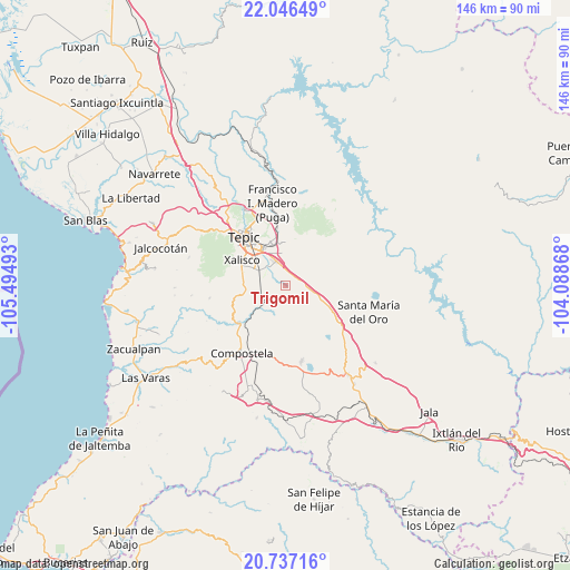
Trigomil GPS coordinates[2]
21° 23' 35.844" North, 104° 47' 30.48" West
| Map corner | latitude | longitude |
|---|---|---|
| Upper-left | 22.04649°, | -105.49493° |
| Center: | 21.39329°, | -104.7918° |
| Lower-right: | 20.73716°, | -104.08868° |
| Map W x H: | 145.6×145.6 km | = 90.5×90.5mi |
| max Lat: | 32.7° ⇑19.2% North |
| Trigomil: | 21.39329° |
| min Lat: | ⇓80.8% South 14.53588° |
| min Long | Trigomil | max Long |
| -117.105° | -104.7918° | -86.73105° |
| W 8.4%⇐ | ⇒91.6% E |
Elevation
Elevation of Trigomil is 997 m = 3271 ft, and this is 256.7 m = 842 ft below average elevation for this country.
| Max E: |
3497 m = 11473 ft | 60.1% |
| Avg. | 1253.7 m = 4113 ft | |
| Trigomil | 997 m = 3271 ft | |
Min E: |
-1 m = -3 ft | 39.9% |
See also: Mexico elevation on elevation.city.
Geographical zone
Trigomil is located in North Torrid zone (between Equator and Tropic of Cancer). Distance of this Northern Tropic circle is 227.2 km =141.2 mi to North.| Distance of | km | miles | from Trigomil |
|---|---|---|---|
| North Pole | 7628.4 | 4740.1 | to North |
| Arctic Circle | 5022.5 | 3120.8 | to North |
| Tropic Cancer | 227.2 | 141.2 | to North |
| Equator | 2378.7 | 1478.1 | to South |


Nearby cities:
15 places around Trigomil: (largest is in red/bold)
• Aquiles Serdán
10.1 km =6.3 mi,  262°
262°
• Camichín de Jauja
8.1 km =5 mi,  353°
353°
• El Refugio
3.1 km =1.9 mi,  34°
34°
• El Verde
7.6 km =4.7 mi,  329°
329°
• Emiliano Zapata
12.9 km =8 mi, 255°
• La Cantera
12.6 km =7.8 mi, 345°
• La Corregidora
6 km =3.7 mi,  339°
339°
• La Curva
6 km =3.7 mi,  231°
231°
• La Labor
7.9 km =4.9 mi,  106°
106°
• Mora
14.9 km =9.3 mi, 352°
• Pantanal
8.2 km =5.1 mi,  298°
298°
• San Cayetano
6.8 km =4.2 mi, 337°
• San Leonel
10.5 km =6.5 mi,  117°
117°
• Testerazo
10.6 km =6.6 mi,  275°
275°
• Xalisco
12.8 km =8 mi, 300°
Sources, notices
• [Note1] Compared only with cities in Mexico existing in our database
• [Src1] Map data: © OpenStreetMap contributors (CC-BY-SA)
• [Src2] Other city data from geonames.org with taken over terms of usage.
• [Src3] Geographical zone / Annual Mean Temperature by Robert A. Rohde @ Wikipedia
