San Cayetano geodata
San Cayetano (Nayarit) is a populated place; located in Mexico in America/Mazatlan (GMT-7) time zone. With population of 4,345 people, there are 2111 cities with bigger population in this country. Compared to other cities in Mexico, 81.1% of cities are located further ↓South; 91.6% of cities are located further →East and 60.8% of cities have higher elevation than San Cayetano. Note1


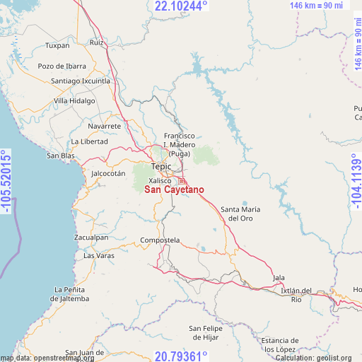
San Cayetano GPS coordinates[2]
21° 26' 58.164" North, 104° 49' 1.272" West
| Map corner | latitude | longitude |
|---|---|---|
| Upper-left | 22.10244°, | -105.52015° |
| Center: | 21.44949°, | -104.81702° |
| Lower-right: | 20.79361°, | -104.1139° |
| Map W x H: | 145.5×145.5 km | = 90.4×90.4mi |
| max Lat: | 32.7° ⇑18.9% North |
| San Cayetano: | 21.44949° |
| min Lat: | ⇓81.1% South 14.53588° |
| min Long | San Cayetano | max Long |
| -117.105° | -104.81702° | -86.73105° |
| W 8.4%⇐ | ⇒91.6% E |
Elevation
Elevation of San Cayetano is 948 m = 3110 ft, and this is 305.7 m = 1003 ft below average elevation for this country.
| Max E: |
3497 m = 11473 ft | 60.8% |
| Avg. | 1253.7 m = 4113 ft | |
| San Cayetano | 948 m = 3110 ft | |
Min E: |
-1 m = -3 ft | 39.2% |
See also: Mexico elevation on elevation.city.
Geographical zone
San Cayetano is located in North Torrid zone (between Equator and Tropic of Cancer). Distance of this Northern Tropic circle is 221 km =137.3 mi to North.| Distance of | km | miles | from San Cayetano |
|---|---|---|---|
| North Pole | 7622.1 | 4736.2 | to North |
| Arctic Circle | 5016.2 | 3116.9 | to North |
| Tropic Cancer | 221 | 137.3 | to North |
| Equator | 2385 | 1482 | to South |


Nearby cities:
15 places around San Cayetano: (largest is in red/bold)
• Aquiles Serdán
10.6 km =6.6 mi,  224°
224°
• Camichín de Jauja
2.4 km =1.5 mi,  43°
43°
• El Refugio
5.7 km =3.5 mi,  129°
129°
• El Verde
1.3 km =0.8 mi,  283°
283°
• La Cantera
6 km =3.7 mi,  354°
354°
• La Corregidora
0.8 km =0.5 mi,  139°
139°
• La Curva
10.2 km =6.3 mi,  191°
191°
• La Labor
13.2 km =8.2 mi, 130°
• Mora
8.6 km =5.3 mi,  4°
4°
• Pantanal
5.1 km =3.2 mi,  242°
242°
• San Luis de Lozada
13 km =8.1 mi,  62°
62°
• Tepic
10.5 km =6.5 mi,  309°
309°
• Testerazo
9.6 km =6 mi, 236°
• Trigomil
6.8 km =4.2 mi,  157°
157°
• Xalisco
8.4 km =5.2 mi,  271°
271°
Sources, notices
• [Note1] Compared only with cities in Mexico existing in our database
• [Src1] Map data: © OpenStreetMap contributors (CC-BY-SA)
• [Src2] Other city data from geonames.org with taken over terms of usage.
• [Src3] Geographical zone / Annual Mean Temperature by Robert A. Rohde @ Wikipedia
