La Labor geodata
La Labor (Nayarit) is a populated place; located in Mexico in America/Mazatlan (GMT-7) time zone. With population of 2,774 people, there are 3190 cities with bigger population in this country. Compared to other cities in Mexico, 80.7% of cities are located further ↓South; 91.5% of cities are located further →East and 58.9% of cities have higher elevation than La Labor. Note1


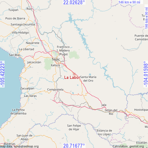
La Labor GPS coordinates[2]
21° 22' 22.764" North, 104° 43' 8.76" West
| Map corner | latitude | longitude |
|---|---|---|
| Upper-left | 22.02628°, | -105.42223° |
| Center: | 21.37299°, | -104.7191° |
| Lower-right: | 20.71677°, | -104.01598° |
| Map W x H: | 145.6×145.6 km | = 90.5×90.5mi |
| max Lat: | 32.7° ⇑19.3% North |
| La Labor: | 21.37299° |
| min Lat: | ⇓80.7% South 14.53588° |
| min Long | La Labor | max Long |
| -117.105° | -104.7191° | -86.73105° |
| W 8.5%⇐ | ⇒91.5% E |
Elevation
Elevation of La Labor is 1058 m = 3471 ft, and this is 195.7 m = 642 ft below average elevation for this country.
| Max E: |
3497 m = 11473 ft | 58.9% |
| Avg. | 1253.7 m = 4113 ft | |
| La Labor | 1058 m = 3471 ft | |
Min E: |
-1 m = -3 ft | 41.1% |
See also: Mexico elevation on elevation.city.
Geographical zone
La Labor is located in North Torrid zone (between Equator and Tropic of Cancer). Distance of this Northern Tropic circle is 229.5 km =142.6 mi to North.| Distance of | km | miles | from La Labor |
|---|---|---|---|
| North Pole | 7630.6 | 4741.4 | to North |
| Arctic Circle | 5024.7 | 3122.2 | to North |
| Tropic Cancer | 229.5 | 142.6 | to North |
| Equator | 2376.5 | 1476.7 | to South |


Nearby cities:
15 places around La Labor: (largest is in red/bold)
• Camichín de Jauja
13.3 km =8.3 mi,  320°
320°
• Cerro Blanco
10.3 km =6.4 mi,  86°
86°
• El Limón
8.3 km =5.2 mi,  101°
101°
• El Refugio
7.5 km =4.7 mi,  310°
310°
• El Verde
14.4 km =8.9 mi, 307°
• La Corregidora
12.5 km =7.8 mi, 309°
• La Curva
12.3 km =7.6 mi,  263°
263°
• Mojarras
12.9 km =8 mi,  62°
62°
• Pantanal
15.9 km =9.9 mi,  292°
292°
• San Cayetano
13.2 km =8.2 mi, 310°
• San Leonel
3.1 km =1.9 mi,  145°
145°
• San Luis de Lozada
14.5 km =9 mi,  5°
5°
• Santa María del Oro
14.4 km =8.9 mi,  107°
107°
• Trigomil
7.9 km =4.9 mi, 286°
• Zapotanito
13.7 km =8.5 mi,  123°
123°
Sources, notices
• [Note1] Compared only with cities in Mexico existing in our database
• [Src1] Map data: © OpenStreetMap contributors (CC-BY-SA)
• [Src2] Other city data from geonames.org with taken over terms of usage.
• [Src3] Geographical zone / Annual Mean Temperature by Robert A. Rohde @ Wikipedia
