Tlalchapa geodata
Tlalchapa (Guerrero) is a seat of a second-order administrative division; located in Mexico in America/Mexico_City (GMT-6) time zone. With population of 4,067 people, there are 2242 cities with bigger population in this country. Compared to other cities in Mexico, 73.7% of cities are located further ↑North; 69.3% of cities are located further →East and 70.2% of cities have higher elevation than Tlalchapa. Note1


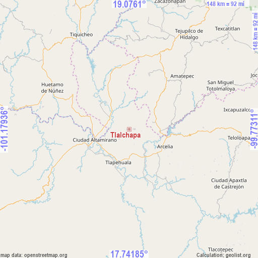
Tlalchapa GPS coordinates[2]
18° 24' 36.972" North, 100° 28' 34.428" West
| Map corner | latitude | longitude |
|---|---|---|
| Upper-left | 19.0761°, | -101.17936° |
| Center: | 18.41027°, | -100.47623° |
| Lower-right: | 17.74185°, | -99.77311° |
| Map W x H: | 148.4×148.4 km | = 92.2×92.2mi |
| max Lat: | 32.7° ⇑73.7% North |
| Tlalchapa: | 18.41027° |
| min Lat: | ⇓26.3% South 14.53588° |
| min Long | Tlalchapa | max Long |
| -117.105° | -100.47623° | -86.73105° |
| W 30.7%⇐ | ⇒69.3% E |
Elevation
Elevation of Tlalchapa is 409 m = 1342 ft, and this is 844.7 m = 2771 ft below average elevation for this country.
| Max E: |
3497 m = 11473 ft | 70.2% |
| Avg. | 1253.7 m = 4113 ft | |
| Tlalchapa | 409 m = 1342 ft | |
Min E: |
-1 m = -3 ft | 29.8% |
See also: Mexico elevation on elevation.city.
Geographical zone
Tlalchapa is located in North Torrid zone (between Equator and Tropic of Cancer). Distance of this Northern Tropic circle is 558.9 km =347.3 mi to North.| Distance of | km | miles | from Tlalchapa |
|---|---|---|---|
| North Pole | 7960 | 4946.1 | to North |
| Arctic Circle | 5354.1 | 3326.9 | to North |
| Tropic Cancer | 558.9 | 347.3 | to North |
| Equator | 2047 | 1271.9 | to South |


Nearby cities:
15 places around Tlalchapa: (largest is in red/bold)
• Chacamerito
15.4 km =9.6 mi,  230°
230°
• Colonia Juárez (El Jabalí)
14.5 km =9 mi,  173°
173°
• Cuadrilla Nueva
10.3 km =6.4 mi,  283°
283°
• Cuauhlotitlán
17.2 km =10.7 mi,  114°
114°
• Cutzamala de Pinzón
12.8 km =8 mi,  300°
300°
• La Bolsa
12.7 km =7.9 mi,  263°
263°
• Otlatepec (Agua del Padre)
11.2 km =7 mi,  347°
347°
• Rincón Grande
14.1 km =8.8 mi,  73°
73°
• Rincón del Gallo (San José Guadalupe)
15.5 km =9.6 mi,  192°
192°
• Salguero
15.8 km =9.8 mi,  271°
271°
• San Antonio de las Huertas
15 km =9.3 mi,  197°
197°
• San Antonio del Rosario
17.7 km =11 mi,  93°
93°
• San Miguel Tecomatlán
12.9 km =8 mi,  142°
142°
• Santa Cruz de Villa Gómez
16.8 km =10.4 mi, 256°
• Villa Madero
2.9 km =1.8 mi, 87°
Sources, notices
• [Note1] Compared only with cities in Mexico existing in our database
• [Src1] Map data: © OpenStreetMap contributors (CC-BY-SA)
• [Src2] Other city data from geonames.org with taken over terms of usage.
• [Src3] Geographical zone / Annual Mean Temperature by Robert A. Rohde @ Wikipedia
