Otlatepec (Agua del Padre) geodata
Otlatepec (Agua del Padre) (Guerrero) is a populated place; located in Mexico in America/Mexico_City (GMT-6) time zone. With population of 696 people, there are 12503 cities with bigger population in this country. Compared to other cities in Mexico, 72.5% of cities are located further ↑North; 69.5% of cities are located further →East and 71.4% of cities have higher elevation than Otlatepec (Agua del Padre). Note1
Current local time in Otlatepec (Agua del Padre):
11:33 AM, MondayDifference from your time zone: hours


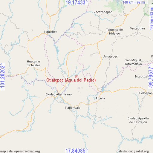
Otlatepec (Agua del Padre) GPS coordinates[2]
18° 30' 32.004" North, 100° 29' 56.004" West
| Map corner | latitude | longitude |
|---|---|---|
| Upper-left | 19.17433°, | -101.20202° |
| Center: | 18.50889°, | -100.49889° |
| Lower-right: | 17.84085°, | -99.79577° |
| Map W x H: | 148.3×148.3 km | = 92.1×92.1mi |
| max Lat: | 32.7° ⇑72.5% North |
| Otlatepec (Agua del Padre): | 18.50889° |
| min Lat: | ⇓27.5% South 14.53588° |
| min Long | Otlatepec (Agua | max Long |
| -117.105° | -100.49889° | -86.73105° |
| W 30.5%⇐ | ⇒69.5% E |
Elevation
Elevation of Otlatepec (Agua del Padre) is 354 m = 1161 ft, and this is 899.7 m = 2952 ft below average elevation for this country.
| Max E: |
3497 m = 11473 ft | 71.4% |
| Avg. | 1253.7 m = 4113 ft | |
| Otlatepec (Agua del Padre) | 354 m = 1161 ft | |
Min E: |
-1 m = -3 ft | 28.6% |
See also: Mexico elevation on elevation.city.
Geographical zone
Otlatepec (Agua del Padre) is located in North Torrid zone (between Equator and Tropic of Cancer). Distance of this Northern Tropic circle is 547.9 km =340.4 mi to North.| Distance of | km | miles | from Otlatepec (Agua del Padre) |
|---|---|---|---|
| North Pole | 7949.1 | 4939.3 | to North |
| Arctic Circle | 5343.2 | 3320.1 | to North |
| Tropic Cancer | 547.9 | 340.4 | to North |
| Equator | 2058 | 1278.8 | to South |


Nearby cities:
15 places around Otlatepec (Agua del Padre): (largest is in red/bold)
• Cuadrilla Nueva
11.4 km =7.1 mi,  222°
222°
• Cutzamala de Pinzón
9.8 km =6.1 mi,  242°
242°
• El Salitre (Sirapitiro)
12.9 km =8 mi,  317°
317°
• La Bolsa
16.1 km =10 mi, 219°
• Mayaltepec
15.8 km =9.8 mi,  58°
58°
• Nuevo Galeana
14.2 km =8.8 mi,  286°
286°
• Palmar Grande
12.4 km =7.7 mi,  49°
49°
• Rincón Grande
17.3 km =10.7 mi,  113°
113°
• Salguero
17 km =10.6 mi,  231°
231°
• San Pedro Limón
21.8 km =13.5 mi,  68°
68°
• Santa Cruz de Villa Gómez
20.4 km =12.7 mi, 223°
• Tamácuaro
16.2 km =10.1 mi,  264°
264°
• Tlalchapa
11.2 km =7 mi,  167°
167°
• Villa Madero
12.1 km =7.5 mi,  153°
153°
• Zacapuato
21.1 km =13.1 mi,  327°
327°
Sources, notices
• [Note1] Compared only with cities in Mexico existing in our database
• [Src1] Map data: © OpenStreetMap contributors (CC-BY-SA)
• [Src2] Other city data from geonames.org with taken over terms of usage.
• [Src3] Geographical zone / Annual Mean Temperature by Robert A. Rohde @ Wikipedia
