Cutzamala de Pinzón geodata
Cutzamala de Pinzón (Guerrero) is a seat of a second-order administrative division; located in Mexico in America/Mexico_City (GMT-6) time zone. With population of 4,895 people, there are 1888 cities with bigger population in this country. Compared to other cities in Mexico, 73% of cities are located further ↑North; 70.2% of cities are located further →East and 73.1% of cities have higher elevation than Cutzamala de Pinzón. Note1


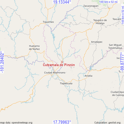
Cutzamala de Pinzón GPS coordinates[2]
18° 28' 4.188" North, 100° 34' 51.204" West
| Map corner | latitude | longitude |
|---|---|---|
| Upper-left | 19.13344°, | -101.28402° |
| Center: | 18.46783°, | -100.58089° |
| Lower-right: | 17.79963°, | -99.87777° |
| Map W x H: | 148.3×148.3 km | = 92.1×92.1mi |
| max Lat: | 32.7° ⇑73% North |
| Cutzamala de Pinzón: | 18.46783° |
| min Lat: | ⇓27% South 14.53588° |
| min Long | Cutzamala de Pi | max Long |
| -117.105° | -100.58089° | -86.73105° |
| W 29.8%⇐ | ⇒70.2% E |
Elevation
Elevation of Cutzamala de Pinzón is 282 m = 925 ft, and this is 971.7 m = 3188 ft below average elevation for this country.
| Max E: |
3497 m = 11473 ft | 73.1% |
| Avg. | 1253.7 m = 4113 ft | |
| Cutzamala de Pinzón | 282 m = 925 ft | |
Min E: |
-1 m = -3 ft | 26.9% |
See also: Mexico elevation on elevation.city.
Geographical zone
Cutzamala de Pinzón is located in North Torrid zone (between Equator and Tropic of Cancer). Distance of this Northern Tropic circle is 552.5 km =343.3 mi to North.| Distance of | km | miles | from Cutzamala de Pinzón |
|---|---|---|---|
| North Pole | 7953.6 | 4942.1 | to North |
| Arctic Circle | 5347.7 | 3322.9 | to North |
| Tropic Cancer | 552.5 | 343.3 | to North |
| Equator | 2053.4 | 1275.9 | to South |


Nearby cities:
15 places around Cutzamala de Pinzón: (largest is in red/bold)
• Ciudad Altamirano
15.4 km =9.6 mi,  217°
217°
• Cuadrilla Nueva
4 km =2.5 mi,  165°
165°
• El Salitre (Sirapitiro)
14 km =8.7 mi,  359°
359°
• La Bolsa
8 km =5 mi,  191°
191°
• Los Limones
14 km =8.7 mi,  202°
202°
• Nuevo Galeana
10 km =6.2 mi,  330°
330°
• Otlatepec (Agua del Padre)
9.8 km =6.1 mi,  62°
62°
• Querendas
15 km =9.3 mi, 202°
• Salguero
7.6 km =4.7 mi, 218°
• San Jerónimo
13.7 km =8.5 mi, 224°
• Santa Cruz de Villa Gómez
11.6 km =7.2 mi,  207°
207°
• Tacupa
12.5 km =7.8 mi,  238°
238°
• Tamácuaro
8.1 km =5 mi,  292°
292°
• Tlalchapa
12.8 km =8 mi,  120°
120°
• Villa Madero
15.3 km =9.5 mi,  114°
114°
Sources, notices
• [Note1] Compared only with cities in Mexico existing in our database
• [Src1] Map data: © OpenStreetMap contributors (CC-BY-SA)
• [Src2] Other city data from geonames.org with taken over terms of usage.
• [Src3] Geographical zone / Annual Mean Temperature by Robert A. Rohde @ Wikipedia
