El Lampotal geodata
El Lampotal (Zacatecas) is a populated place; located in Mexico in America/Mexico_City (GMT-6) time zone. With population of 1,368 people, there are 6347 cities with bigger population in this country. Compared to other cities in Mexico, 87.8% of cities are located further ↓South; 83.6% of cities are located further →East and 78% of cities have lower elevation than El Lampotal. Note1


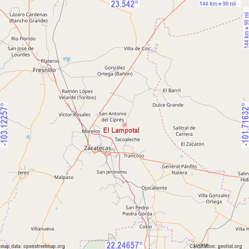
El Lampotal GPS coordinates[2]
22° 53' 44.988" North, 102° 25' 9.984" West
| Map corner | latitude | longitude |
|---|---|---|
| Upper-left | 23.542°, | -103.12257° |
| Center: | 22.89583°, | -102.41944° |
| Lower-right: | 22.24657°, | -101.71632° |
| Map W x H: | 144×144 km | = 89.5×89.5mi |
| max Lat: | 32.7° ⇑12.2% North |
| El Lampotal: | 22.89583° |
| min Lat: | ⇓87.8% South 14.53588° |
| min Long | El Lampotal | max Long |
| -117.105° | -102.41944° | -86.73105° |
| W 16.4%⇐ | ⇒83.6% E |
Elevation
Elevation of El Lampotal is 2089 m = 6854 ft, and this is 835.3 m = 2740 ft above average elevation for this country.
| Max E: |
3497 m = 11473 ft | 22% |
| El Lampotal | 2089 m 6854 ft | |
| Avg. | 1253.7 m = 4113 ft | |
Min E: |
-1 m = -3 ft | 78% |
See also: Mexico elevation on elevation.city.
Geographical zone
El Lampotal is located in North Torrid zone (between Equator and Tropic of Cancer). Distance of this Northern Tropic circle is 60.1 km =37.3 mi to North.| Distance of | km | miles | from El Lampotal |
|---|---|---|---|
| North Pole | 7461.3 | 4636.2 | to North |
| Arctic Circle | 4855.4 | 3017 | to North |
| Tropic Cancer | 60.1 | 37.3 | to North |
| Equator | 2545.8 | 1581.9 | to South |


Nearby cities:
15 places around El Lampotal: (largest is in red/bold)
• Casa Blanca
11.6 km =7.2 mi,  96°
96°
• Casa de Cerros
10.5 km =6.5 mi,  263°
263°
• La Blanquita
12.6 km =7.8 mi,  160°
160°
• La Luz
11.3 km =7 mi, 98°
• Los Pozos
13.5 km =8.4 mi,  327°
327°
• Pánuco
12.7 km =7.9 mi, 260°
• San Antonio del Cipres
8.4 km =5.2 mi,  304°
304°
• San José de la Era
5 km =3.1 mi,  183°
183°
• San Juan
13.6 km =8.5 mi,  16°
16°
• Santa Mónica
15.7 km =9.8 mi, 181°
• Santa Rita
1.8 km =1.1 mi,  3°
3°
• Sauceda de La Borda
11.2 km =7 mi,  229°
229°
• Tacoaleche
8.6 km =5.3 mi,  169°
169°
• Vetagrande
15.6 km =9.7 mi,  243°
243°
• Zoquite
12.3 km =7.6 mi, 181°
Sources, notices
• [Note1] Compared only with cities in Mexico existing in our database
• [Src1] Map data: © OpenStreetMap contributors (CC-BY-SA)
• [Src2] Other city data from geonames.org with taken over terms of usage.
• [Src3] Geographical zone / Annual Mean Temperature by Robert A. Rohde @ Wikipedia
