Zoquite geodata
Zoquite (Zacatecas) is a populated place; located in Mexico in America/Mexico_City (GMT-6) time zone. With population of 3,788 people, there are 2415 cities with bigger population in this country. Compared to other cities in Mexico, 87.5% of cities are located further ↓South; 83.6% of cities are located further →East and 81.3% of cities have lower elevation than Zoquite. Note1


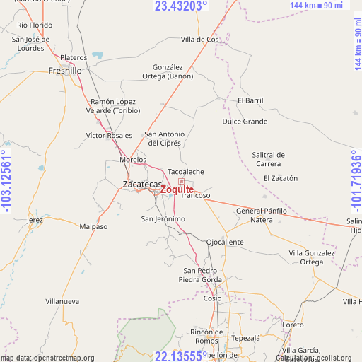
Zoquite GPS coordinates[2]
22° 47' 7.188" North, 102° 25' 20.928" West
| Map corner | latitude | longitude |
|---|---|---|
| Upper-left | 23.43203°, | -103.12561° |
| Center: | 22.78533°, | -102.42248° |
| Lower-right: | 22.13555°, | -101.71936° |
| Map W x H: | 144.2×144.2 km | = 89.6×89.6mi |
| max Lat: | 32.7° ⇑12.5% North |
| Zoquite: | 22.78533° |
| min Lat: | ⇓87.5% South 14.53588° |
| min Long | Zoquite | max Long |
| -117.105° | -102.42248° | -86.73105° |
| W 16.4%⇐ | ⇒83.6% E |
Elevation
Elevation of Zoquite is 2170 m = 7119 ft, and this is 916.3 m = 3006 ft above average elevation for this country.
| Max E: |
3497 m = 11473 ft | 18.7% |
| Zoquite | 2170 m 7119 ft | |
| Avg. | 1253.7 m = 4113 ft | |
Min E: |
-1 m = -3 ft | 81.3% |
See also: Mexico elevation on elevation.city.
Geographical zone
Zoquite is located in North Torrid zone (between Equator and Tropic of Cancer). Distance of this Northern Tropic circle is 72.4 km =45 mi to North.| Distance of | km | miles | from Zoquite |
|---|---|---|---|
| North Pole | 7473.6 | 4643.9 | to North |
| Arctic Circle | 4867.7 | 3024.6 | to North |
| Tropic Cancer | 72.4 | 45 | to North |
| Equator | 2533.5 | 1574.2 | to South |


Nearby cities:
15 places around Zoquite: (largest is in red/bold)
• Casa de Cerros
15 km =9.3 mi,  317°
317°
• Cieneguitas
10.8 km =6.7 mi,  222°
222°
• El Lampotal
12.3 km =7.6 mi,  1°
1°
• Guadalupe
10.7 km =6.6 mi,  246°
246°
• La Blanquita
4.6 km =2.9 mi,  85°
85°
• La Zacatecana
8.1 km =5 mi, 221°
• Martínez Domínguez
7.3 km =4.5 mi,  235°
235°
• San José de la Era
7.3 km =4.5 mi, 0°
• San Ramón
14.3 km =8.9 mi,  227°
227°
• Santa Mónica
3.4 km =2.1 mi,  179°
179°
• Santa Rita
14.1 km =8.8 mi, 1°
• Sauceda de La Borda
9.6 km =6 mi,  301°
301°
• Tacoaleche
4.3 km =2.7 mi,  25°
25°
• Trancoso
7.9 km =4.9 mi,  134°
134°
• Vetagrande
14.7 km =9.1 mi,  291°
291°
Sources, notices
• [Note1] Compared only with cities in Mexico existing in our database
• [Src1] Map data: © OpenStreetMap contributors (CC-BY-SA)
• [Src2] Other city data from geonames.org with taken over terms of usage.
• [Src3] Geographical zone / Annual Mean Temperature by Robert A. Rohde @ Wikipedia
