Susticacán geodata
Susticacán (Zacatecas) is a seat of a second-order administrative division; located in Mexico in America/Mexico_City (GMT-6) time zone. With population of 932 people, there are 9352 cities with bigger population in this country. Compared to other cities in Mexico, 87% of cities are located further ↓South; 86.1% of cities are located further →East and 75.3% of cities have lower elevation than Susticacán. Note1


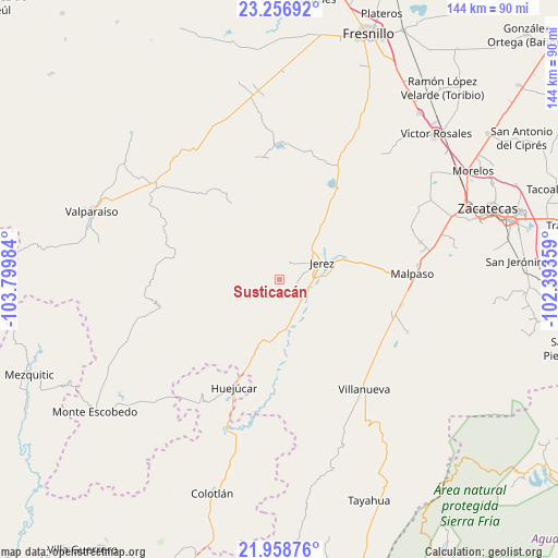
Susticacán GPS coordinates[2]
22° 36' 33.732" North, 103° 5' 48.156" West
| Map corner | latitude | longitude |
|---|---|---|
| Upper-left | 23.25692°, | -103.79984° |
| Center: | 22.60937°, | -103.09671° |
| Lower-right: | 21.95876°, | -102.39359° |
| Map W x H: | 144.3×144.3 km | = 89.7×89.7mi |
| max Lat: | 32.7° ⇑13% North |
| Susticacán: | 22.60937° |
| min Lat: | ⇓87% South 14.53588° |
| min Long | Susticacán | max Long |
| -117.105° | -103.09671° | -86.73105° |
| W 13.9%⇐ | ⇒86.1% E |
Elevation
Elevation of Susticacán is 2036 m = 6680 ft, and this is 782.3 m = 2567 ft above average elevation for this country.
| Max E: |
3497 m = 11473 ft | 24.7% |
| Susticacán | 2036 m 6680 ft | |
| Avg. | 1253.7 m = 4113 ft | |
Min E: |
-1 m = -3 ft | 75.3% |
See also: Mexico elevation on elevation.city.
Geographical zone
Susticacán is located in North Torrid zone (between Equator and Tropic of Cancer). Distance of this Northern Tropic circle is 92 km =57.2 mi to North.| Distance of | km | miles | from Susticacán |
|---|---|---|---|
| North Pole | 7493.1 | 4656 | to North |
| Arctic Circle | 4887.2 | 3036.8 | to North |
| Tropic Cancer | 92 | 57.2 | to North |
| Equator | 2513.9 | 1562.1 | to South |


Nearby cities:
15 places around Susticacán: (largest is in red/bold)
• Colonia Felipe Ángeles
32 km =19.9 mi,  102°
102°
• El Salto
33.8 km =21 mi,  153°
153°
• El Tigre
26.2 km =16.3 mi,  135°
135°
• Ermita de Guadalupe
7.2 km =4.5 mi,  111°
111°
• Ermita de los Correas
34.1 km =21.2 mi,  14°
14°
• Huejúcar
30.2 km =18.8 mi,  202°
202°
• Jerez de García Salinas
11.8 km =7.3 mi,  67°
67°
• La Quemada
33.2 km =20.6 mi,  128°
128°
• Los Haros
22.2 km =13.8 mi,  38°
38°
• Malpaso
34.4 km =21.4 mi,  86°
86°
• Santa Rita (Luis Moya)
20.8 km =12.9 mi,  49°
49°
• Santa Rosa
35.5 km =22.1 mi,  357°
357°
• Tepetongo
17.7 km =11 mi, 198°
• Villanueva
35.8 km =22.2 mi, 142°
• Víboras
22.9 km =14.2 mi, 199°
Sources, notices
• [Note1] Compared only with cities in Mexico existing in our database
• [Src1] Map data: © OpenStreetMap contributors (CC-BY-SA)
• [Src2] Other city data from geonames.org with taken over terms of usage.
• [Src3] Geographical zone / Annual Mean Temperature by Robert A. Rohde @ Wikipedia
