El Tigre geodata
El Tigre (Zacatecas) is a populated place; located in Mexico in America/Mexico_City (GMT-6) time zone. With population of 501 people, there are 16785 cities with bigger population in this country. Compared to other cities in Mexico, 86.5% of cities are located further ↓South; 85.5% of cities are located further →East and 74.7% of cities have lower elevation than El Tigre. Note1


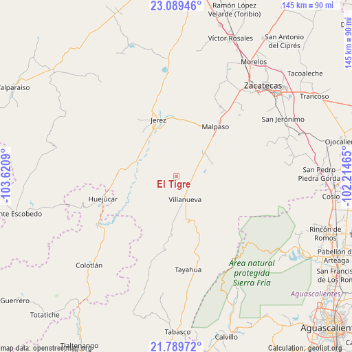
El Tigre GPS coordinates[2]
22° 26' 27.996" North, 102° 55' 3.972" West
| Map corner | latitude | longitude |
|---|---|---|
| Upper-left | 23.08946°, | -103.6209° |
| Center: | 22.44111°, | -102.91777° |
| Lower-right: | 21.78972°, | -102.21465° |
| Map W x H: | 144.5×144.5 km | = 89.8×89.8mi |
| max Lat: | 32.7° ⇑13.5% North |
| El Tigre: | 22.44111° |
| min Lat: | ⇓86.5% South 14.53588° |
| min Long | El Tigre | max Long |
| -117.105° | -102.91777° | -86.73105° |
| W 14.5%⇐ | ⇒85.5% E |
Elevation
Elevation of El Tigre is 2024 m = 6640 ft, and this is 770.3 m = 2527 ft above average elevation for this country.
| Max E: |
3497 m = 11473 ft | 25.3% |
| El Tigre | 2024 m 6640 ft | |
| Avg. | 1253.7 m = 4113 ft | |
Min E: |
-1 m = -3 ft | 74.7% |
See also: Mexico elevation on elevation.city.
Geographical zone
El Tigre is located in North Torrid zone (between Equator and Tropic of Cancer). Distance of this Northern Tropic circle is 110.7 km =68.8 mi to North.| Distance of | km | miles | from El Tigre |
|---|---|---|---|
| North Pole | 7511.8 | 4667.6 | to North |
| Arctic Circle | 4906 | 3048.4 | to North |
| Tropic Cancer | 110.7 | 68.8 | to North |
| Equator | 2495.2 | 1550.4 | to South |


Nearby cities:
15 places around El Tigre: (largest is in red/bold)
• Colonia Felipe Ángeles
17.6 km =10.9 mi,  47°
47°
• El Fuerte
29.6 km =18.4 mi,  37°
37°
• El Salto
12 km =7.5 mi,  195°
195°
• Ermita de Guadalupe
19.9 km =12.4 mi,  324°
324°
• Huejúcar
31.5 km =19.6 mi,  253°
253°
• Jerez de García Salinas
24.4 km =15.2 mi,  342°
342°
• La Encarnación
21.7 km =13.5 mi,  181°
181°
• La Quemada
7.9 km =4.9 mi,  104°
104°
• Malpaso
26.1 km =16.2 mi, 37°
• Santa Rita (Luis Moya)
32.2 km =20 mi,  355°
355°
• Susticacán
26.2 km =16.3 mi, 315°
• Tepetongo
24.1 km =15 mi,  274°
274°
• Tlacosahua
32 km =19.9 mi,  234°
234°
• Villanueva
10.2 km =6.3 mi,  159°
159°
• Víboras
26.2 km =16.3 mi,  263°
263°
Sources, notices
• [Note1] Compared only with cities in Mexico existing in our database
• [Src1] Map data: © OpenStreetMap contributors (CC-BY-SA)
• [Src2] Other city data from geonames.org with taken over terms of usage.
• [Src3] Geographical zone / Annual Mean Temperature by Robert A. Rohde @ Wikipedia
