La Quemada geodata
La Quemada (Zacatecas) is a populated place; located in Mexico in America/Mexico_City (GMT-6) time zone. With population of 936 people, there are 9311 cities with bigger population in this country. Compared to other cities in Mexico, 86.4% of cities are located further ↓South; 85.2% of cities are located further →East and 72.5% of cities have lower elevation than La Quemada. Note1


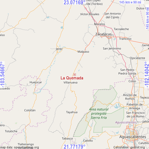
La Quemada GPS coordinates[2]
22° 25' 23.736" North, 102° 50' 36.744" West
| Map corner | latitude | longitude |
|---|---|---|
| Upper-left | 23.07169°, | -103.54667° |
| Center: | 22.42326°, | -102.84354° |
| Lower-right: | 21.77179°, | -102.14042° |
| Map W x H: | 144.5×144.5 km | = 89.8×89.8mi |
| max Lat: | 32.7° ⇑13.6% North |
| La Quemada: | 22.42326° |
| min Lat: | ⇓86.4% South 14.53588° |
| min Long | La Quemada | max Long |
| -117.105° | -102.84354° | -86.73105° |
| W 14.8%⇐ | ⇒85.2% E |
Elevation
Elevation of La Quemada is 1978 m = 6490 ft, and this is 724.3 m = 2376 ft above average elevation for this country.
| Max E: |
3497 m = 11473 ft | 27.5% |
| La Quemada | 1978 m 6490 ft | |
| Avg. | 1253.7 m = 4113 ft | |
Min E: |
-1 m = -3 ft | 72.5% |
See also: Mexico elevation on elevation.city.
Geographical zone
La Quemada is located in North Torrid zone (between Equator and Tropic of Cancer). Distance of this Northern Tropic circle is 112.7 km =70 mi to North.| Distance of | km | miles | from La Quemada |
|---|---|---|---|
| North Pole | 7513.8 | 4668.9 | to North |
| Arctic Circle | 4907.9 | 3049.6 | to North |
| Tropic Cancer | 112.7 | 70 | to North |
| Equator | 2493.2 | 1549.2 | to South |


Nearby cities:
15 places around La Quemada: (largest is in red/bold)
• Benito Juárez
32.2 km =20 mi,  19°
19°
• Colonia Felipe Ángeles
14.9 km =9.3 mi, 20°
• El Fuerte
27.4 km =17 mi, 22°
• El Salto
14.5 km =9 mi,  228°
228°
• El Tigre
7.9 km =4.9 mi,  284°
284°
• Ermita de Guadalupe
26.4 km =16.4 mi,  313°
313°
• González Ortega (Machines)
30.1 km =18.7 mi,  25°
25°
• Jerez de García Salinas
29.3 km =18.2 mi,  329°
329°
• La Encarnación
21.4 km =13.3 mi,  203°
203°
• Malpaso
24.1 km =15 mi, 20°
• Perales
32.6 km =20.3 mi,  65°
65°
• Susticacán
33.2 km =20.6 mi, 308°
• Tepetongo
31.9 km =19.8 mi, 277°
• Villanueva
8.6 km =5.3 mi,  208°
208°
• Víboras
33.7 km =20.9 mi,  268°
268°
Sources, notices
• [Note1] Compared only with cities in Mexico existing in our database
• [Src1] Map data: © OpenStreetMap contributors (CC-BY-SA)
• [Src2] Other city data from geonames.org with taken over terms of usage.
• [Src3] Geographical zone / Annual Mean Temperature by Robert A. Rohde @ Wikipedia
