Malpaso geodata
Malpaso (Zacatecas) is a populated place; located in Mexico in America/Mexico_City (GMT-6) time zone. With population of 3,207 people, there are 2825 cities with bigger population in this country. Compared to other cities in Mexico, 87.1% of cities are located further ↓South; 85% of cities are located further →East and 80.5% of cities have lower elevation than Malpaso. Note1


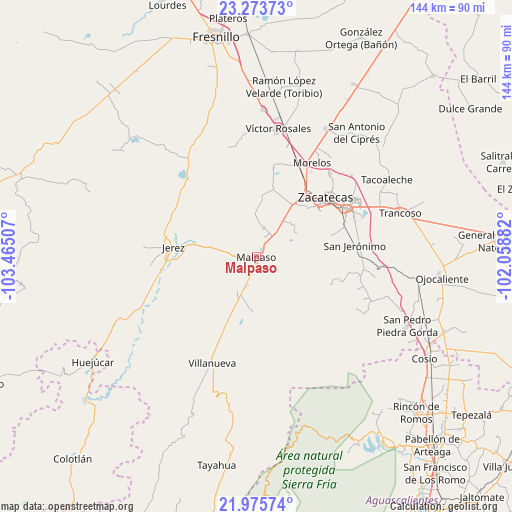
Malpaso GPS coordinates[2]
22° 37' 34.572" North, 102° 45' 42.984" West
| Map corner | latitude | longitude |
|---|---|---|
| Upper-left | 23.27373°, | -103.46507° |
| Center: | 22.62627°, | -102.76194° |
| Lower-right: | 21.97574°, | -102.05882° |
| Map W x H: | 144.3×144.3 km | = 89.7×89.7mi |
| max Lat: | 32.7° ⇑12.9% North |
| Malpaso: | 22.62627° |
| min Lat: | ⇓87.1% South 14.53588° |
| min Long | Malpaso | max Long |
| -117.105° | -102.76194° | -86.73105° |
| W 15%⇐ | ⇒85% E |
Elevation
Elevation of Malpaso is 2152 m = 7060 ft, and this is 898.3 m = 2947 ft above average elevation for this country.
| Max E: |
3497 m = 11473 ft | 19.5% |
| Malpaso | 2152 m 7060 ft | |
| Avg. | 1253.7 m = 4113 ft | |
Min E: |
-1 m = -3 ft | 80.5% |
See also: Mexico elevation on elevation.city.
Geographical zone
Malpaso is located in North Torrid zone (between Equator and Tropic of Cancer). Distance of this Northern Tropic circle is 90.1 km =56 mi to North.| Distance of | km | miles | from Malpaso |
|---|---|---|---|
| North Pole | 7491.3 | 4654.9 | to North |
| Arctic Circle | 4885.4 | 3035.6 | to North |
| Tropic Cancer | 90.1 | 56 | to North |
| Equator | 2515.8 | 1563.2 | to South |


Nearby cities:
15 places around Malpaso: (largest is in red/bold)
• Bañuelos
25.4 km =15.8 mi,  83°
83°
• Benito Juárez
8.2 km =5.1 mi,  15°
15°
• Cieneguillas
17.7 km =11 mi,  35°
35°
• Colonia Felipe Ángeles
9.2 km =5.7 mi,  199°
199°
• El Fuerte
3.5 km =2.2 mi, 37°
• Francisco I. Madero
19.5 km =12.1 mi,  13°
13°
• García de la Cadena
13.5 km =8.4 mi,  48°
48°
• González Ortega (Machines)
6.4 km =4 mi, 43°
• Jerez de García Salinas
23.6 km =14.7 mi,  276°
276°
• La Quemada
24.1 km =15 mi, 200°
• Perales
23.3 km =14.5 mi,  113°
113°
• Picones
19.3 km =12 mi, 42°
• Pimienta
22.7 km =14.1 mi, 36°
• Santa Rita (Luis Moya)
21.8 km =13.5 mi,  301°
301°
• Zacatecas
24.3 km =15.1 mi, 49°
Sources, notices
• [Note1] Compared only with cities in Mexico existing in our database
• [Src1] Map data: © OpenStreetMap contributors (CC-BY-SA)
• [Src2] Other city data from geonames.org with taken over terms of usage.
• [Src3] Geographical zone / Annual Mean Temperature by Robert A. Rohde @ Wikipedia
