Santiago Tangamandapio geodata
Santiago Tangamandapio (Michoacán) is a seat of a second-order administrative division; located in Mexico in America/Mexico_City (GMT-6) time zone. With population of 10,463 people, there are 909 cities with bigger population in this country. Compared to other cities in Mexico, 56.1% of cities are located further ↓South; 83.7% of cities are located further →East and 57.4% of cities have lower elevation than Santiago Tangamandapio. Note1
Current local time in Santiago Tangamandapio:
09:47 PM, TuesdayDifference from your time zone: hours


Santiago Tangamandapio GPS coordinates[2]
19° 57' 20.448" North, 102° 26' 7.656" West
| Map corner | latitude | longitude |
|---|---|---|
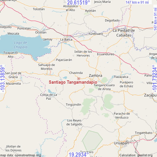
| Upper-left | 20.61519°, | -103.13859° |
| Center: | 19.95568°, | -102.43546° |
| Lower-right: | 19.2934°, | -101.73234° |
| Map W x H: | 147×147 km | = 91.3×91.3mi |
| max Lat: | 32.7° ⇑43.9% North |
| Santiago Tangamandapio: | 19.95568° |
| min Lat: | ⇓56.1% South 14.53588° |
| min Long | Santiago Tangam | max Long |
| -117.105° | -102.43546° | -86.73105° |
| W 16.3%⇐ | ⇒83.7% E |
Elevation
Elevation of Santiago Tangamandapio is 1673 m = 5489 ft, and this is 419.3 m = 1376 ft above average elevation for this country.
| Max E: |
3497 m = 11473 ft | 42.6% |
| Santiago Tangamandapio | 1673 m 5489 ft | |
| Avg. | 1253.7 m = 4113 ft | |
Min E: |
-1 m = -3 ft | 57.4% |
See also: Mexico elevation on elevation.city.
Geographical zone
Santiago Tangamandapio is located in North Torrid zone (between Equator and Tropic of Cancer). Distance of this Northern Tropic circle is 387.1 km =240.5 mi to North.| Distance of | km | miles | from Santiago Tangamandapio |
|---|---|---|---|
| North Pole | 7788.2 | 4839.4 | to North |
| Arctic Circle | 5182.3 | 3220.1 | to North |
| Tropic Cancer | 387.1 | 240.5 | to North |
| Equator | 2218.9 | 1378.8 | to South |


Nearby cities:
15 places around Santiago Tangamandapio: (largest is in red/bold)
• Ario de Rayón
12.1 km =7.5 mi,  49°
49°
• Cerrito Colorado
11.3 km =7 mi,  300°
300°
• Chavinda
6.2 km =3.9 mi,  335°
335°
• Churintzio
3.7 km =2.3 mi, 301°
• El Guayabito
1.1 km =0.7 mi,  233°
233°
• El Llano
10.2 km =6.3 mi,  35°
35°
• Jacona de Plancarte
13.3 km =8.3 mi,  91°
91°
• La Cantera
10.6 km =6.6 mi,  164°
164°
• La Esperanza
11.4 km =7.1 mi,  12°
12°
• Las Estacas
11.6 km =7.2 mi,  244°
244°
• Los Hucuares
9 km =5.6 mi, 225°
• Rancho Nuevo (Joyas del Pedregal)
8.7 km =5.4 mi,  80°
80°
• San Antonio Guaracha
12.6 km =7.8 mi,  265°
265°
• Tarécuato
12.8 km =8 mi,  193°
193°
• Telonzo
2.2 km =1.4 mi,  320°
320°
Sources, notices
• [Note1] Compared only with cities in Mexico existing in our database
• [Src1] Map data: © OpenStreetMap contributors (CC-BY-SA)
• [Src2] Other city data from geonames.org with taken over terms of usage.
• [Src3] Geographical zone / Annual Mean Temperature by Robert A. Rohde @ Wikipedia
