Santa Teresa geodata
Santa Teresa (Nayarit) is a populated place; located in Mexico in America/Mazatlan (GMT-7) time zone. With population of 1,558 people, there are 5539 cities with bigger population in this country. Compared to other cities in Mexico, 86.7% of cities are located further ↓South; 91.5% of cities are located further →East and 79.1% of cities have lower elevation than Santa Teresa. Note1


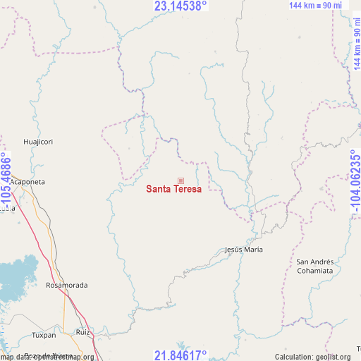
Santa Teresa GPS coordinates[2]
22° 29' 50.28" North, 104° 45' 55.692" West
| Map corner | latitude | longitude |
|---|---|---|
| Upper-left | 23.14538°, | -105.4686° |
| Center: | 22.4973°, | -104.76547° |
| Lower-right: | 21.84617°, | -104.06235° |
| Map W x H: | 144.5×144.5 km | = 89.8×89.8mi |
| max Lat: | 32.7° ⇑13.3% North |
| Santa Teresa: | 22.4973° |
| min Lat: | ⇓86.7% South 14.53588° |
| min Long | Santa Teresa | max Long |
| -117.105° | -104.76547° | -86.73105° |
| W 8.5%⇐ | ⇒91.5% E |
Elevation
Elevation of Santa Teresa is 2120 m = 6955 ft, and this is 866.3 m = 2842 ft above average elevation for this country.
| Max E: |
3497 m = 11473 ft | 20.9% |
| Santa Teresa | 2120 m 6955 ft | |
| Avg. | 1253.7 m = 4113 ft | |
Min E: |
-1 m = -3 ft | 79.1% |
See also: Mexico elevation on elevation.city.
Geographical zone
Santa Teresa is located in North Torrid zone (between Equator and Tropic of Cancer). Distance of this Northern Tropic circle is 104.5 km =64.9 mi to North.| Distance of | km | miles | from Santa Teresa |
|---|---|---|---|
| North Pole | 7505.6 | 4663.8 | to North |
| Arctic Circle | 4899.7 | 3044.5 | to North |
| Tropic Cancer | 104.5 | 64.9 | to North |
| Equator | 2501.5 | 1554.4 | to South |


Nearby cities:
15 places around Santa Teresa: (largest is in red/bold)
• Bancos de Calitique
38.5 km =23.9 mi,  98°
98°
• Huazamota
27.8 km =17.3 mi,  83°
83°
• Jesús María
37.4 km =23.2 mi,  137°
137°
• Linda Vista
12.9 km =8 mi,  207°
207°
• Llano Grande
47.7 km =29.6 mi,  31°
31°
• Mesa del Nayar
33.2 km =20.6 mi,  159°
159°
• Mojocuautla (Adjuntas)
54 km =33.6 mi, 211°
• Presidio de los Reyes
53.7 km =33.4 mi,  198°
198°
• San Andrés Milpillas
54.5 km =33.9 mi,  318°
318°
• San Francisco
35.9 km =22.3 mi,  130°
130°
• San Juan Bautista
52.1 km =32.4 mi,  220°
220°
• San Pedro Ixcatan
53.7 km =33.4 mi, 198°
• Santa Lucía de la Sierra
56.4 km =35 mi,  93°
93°
• Santa María de Ocotán
49.6 km =30.8 mi,  20°
20°
• Teponahuaxtla
53.2 km =33.1 mi,  235°
235°
Sources, notices
• [Note1] Compared only with cities in Mexico existing in our database
• [Src1] Map data: © OpenStreetMap contributors (CC-BY-SA)
• [Src2] Other city data from geonames.org with taken over terms of usage.
• [Src3] Geographical zone / Annual Mean Temperature by Robert A. Rohde @ Wikipedia
