Huazamota geodata
Huazamota (Durango) is a populated place; located in Mexico in America/Monterrey (GMT-6) time zone. With population of 877 people, there are 9961 cities with bigger population in this country. Compared to other cities in Mexico, 86.8% of cities are located further ↓South; 90.9% of cities are located further →East and 66.7% of cities have higher elevation than Huazamota. Note1


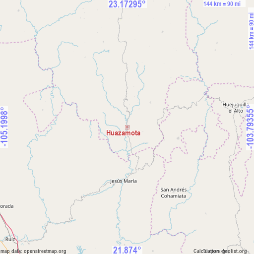
Huazamota GPS coordinates[2]
22° 31' 30" North, 104° 29' 48.012" West
| Map corner | latitude | longitude |
|---|---|---|
| Upper-left | 23.17295°, | -105.1998° |
| Center: | 22.525°, | -104.49667° |
| Lower-right: | 21.874°, | -103.79355° |
| Map W x H: | 144.4×144.4 km | = 89.7×89.7mi |
| max Lat: | 32.7° ⇑13.2% North |
| Huazamota: | 22.525° |
| min Lat: | ⇓86.8% South 14.53588° |
| min Long | Huazamota | max Long |
| -117.105° | -104.49667° | -86.73105° |
| W 9.1%⇐ | ⇒90.9% E |
Elevation
Elevation of Huazamota is 600 m = 1969 ft, and this is 653.7 m = 2145 ft below average elevation for this country.
| Max E: |
3497 m = 11473 ft | 66.7% |
| Avg. | 1253.7 m = 4113 ft | |
| Huazamota | 600 m = 1969 ft | |
Min E: |
-1 m = -3 ft | 33.3% |
See also: Mexico elevation on elevation.city.
Geographical zone
Huazamota is located in North Torrid zone (between Equator and Tropic of Cancer). Distance of this Northern Tropic circle is 101.4 km =63 mi to North.| Distance of | km | miles | from Huazamota |
|---|---|---|---|
| North Pole | 7502.5 | 4661.8 | to North |
| Arctic Circle | 4896.6 | 3042.6 | to North |
| Tropic Cancer | 101.4 | 63 | to North |
| Equator | 2504.5 | 1556.2 | to South |


Nearby cities:
15 places around Huazamota: (largest is in red/bold)
• Bancos de Calitique
13.7 km =8.5 mi,  130°
130°
• Huejuquilla el Alto
62.5 km =38.8 mi,  79°
79°
• Jesús María
30.6 km =19 mi,  184°
184°
• Linda Vista
36.6 km =22.7 mi,  246°
246°
• Llano Grande
37.9 km =23.5 mi,  355°
355°
• Mesa del Nayar
37.8 km =23.5 mi,  205°
205°
• San Andrés Cohamiata
45.7 km =28.4 mi,  144°
144°
• San Francisco
26.3 km =16.3 mi, 180°
• San Juan Capistrano
42.7 km =26.5 mi,  72°
72°
• San Miguel (San Miguel Huaixtita)
53.7 km =33.4 mi,  160°
160°
• San Rafael de las Tablas
50.8 km =31.6 mi,  53°
53°
• Santa Lucía de la Sierra
29.4 km =18.3 mi,  101°
101°
• Santa María de Ocotán
44.8 km =27.8 mi,  346°
346°
• Santa Teresa
27.8 km =17.3 mi,  263°
263°
• Tenzompa
61 km =37.9 mi,  106°
106°
Sources, notices
• [Note1] Compared only with cities in Mexico existing in our database
• [Src1] Map data: © OpenStreetMap contributors (CC-BY-SA)
• [Src2] Other city data from geonames.org with taken over terms of usage.
• [Src3] Geographical zone / Annual Mean Temperature by Robert A. Rohde @ Wikipedia
