San Diego de Alejandría geodata
San Diego de Alejandría (Jalisco) is a seat of a second-order administrative division; located in Mexico in America/Mexico_City (GMT-6) time zone. With population of 5,312 people, there are 1743 cities with bigger population in this country. Compared to other cities in Mexico, 76.4% of cities are located further ↓South; 80.9% of cities are located further →East and 71.1% of cities have lower elevation than San Diego de Alejandría. Note1
Current local time in San Diego de Alejandría:
06:51 AM, WednesdayDifference from your time zone: hours


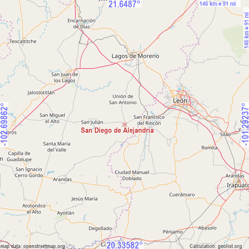
San Diego de Alejandría GPS coordinates[2]
20° 59' 37.32" North, 101° 59' 43.764" West
| Map corner | latitude | longitude |
|---|---|---|
| Upper-left | 21.6487°, | -102.69862° |
| Center: | 20.9937°, | -101.99549° |
| Lower-right: | 20.33582°, | -101.29237° |
| Map W x H: | 146×146 km | = 90.7×90.7mi |
| max Lat: | 32.7° ⇑23.6% North |
| San Diego de Alejandría: | 20.9937° |
| min Lat: | ⇓76.4% South 14.53588° |
| min Long | San Diego de Al | max Long |
| -117.105° | -101.99549° | -86.73105° |
| W 19.1%⇐ | ⇒80.9% E |
Elevation
Elevation of San Diego de Alejandría is 1947 m = 6388 ft, and this is 693.3 m = 2275 ft above average elevation for this country.
| Max E: |
3497 m = 11473 ft | 28.9% |
| San Diego de Alejandría | 1947 m 6388 ft | |
| Avg. | 1253.7 m = 4113 ft | |
Min E: |
-1 m = -3 ft | 71.1% |
See also: Mexico elevation on elevation.city.
Geographical zone
San Diego de Alejandría is located in North Torrid zone (between Equator and Tropic of Cancer). Distance of this Northern Tropic circle is 271.6 km =168.8 mi to North.| Distance of | km | miles | from San Diego de Alejandría |
|---|---|---|---|
| North Pole | 7672.8 | 4767.7 | to North |
| Arctic Circle | 5066.9 | 3148.4 | to North |
| Tropic Cancer | 271.6 | 168.8 | to North |
| Equator | 2334.3 | 1450.5 | to South |


Nearby cities:
15 places around San Diego de Alejandría: (largest is in red/bold)
• Cañada de Negros
10.8 km =6.7 mi,  134°
134°
• Dolores
10.9 km =6.8 mi,  116°
116°
• El Refugio
10.8 km =6.7 mi,  108°
108°
• El Tecolote
14.3 km =8.9 mi,  148°
148°
• Fraccionamiento Villa Jardín
14.9 km =9.3 mi,  90°
90°
• Guadalupe de Jalpa
14.9 km =9.3 mi,  173°
173°
• Jalpa de Cánovas
12.7 km =7.9 mi, 174°
• Monte Grande
13.7 km =8.5 mi, 87°
• Purísima de Bustos
12.9 km =8 mi,  70°
70°
• San Bernardo
13.4 km =8.3 mi,  102°
102°
• San Francisco del Rincón
14.8 km =9.2 mi,  79°
79°
• San Jerónimo
12.5 km =7.8 mi, 91°
• San Nicolás del Palenque
9.7 km =6 mi, 95°
• San Ángel
12.9 km =8 mi,  142°
142°
• Unión de San Antonio
14.9 km =9.3 mi,  355°
355°
Sources, notices
• [Note1] Compared only with cities in Mexico existing in our database
• [Src1] Map data: © OpenStreetMap contributors (CC-BY-SA)
• [Src2] Other city data from geonames.org with taken over terms of usage.
• [Src3] Geographical zone / Annual Mean Temperature by Robert A. Rohde @ Wikipedia
