Manzanillo geodata
Manzanillo (Colima) is a seat of a second-order administrative division; located in Mexico in America/Mexico_City (GMT-6) time zone. With population of 130,035 people, there are 111 cities with bigger population in this country. Compared to other cities in Mexico, 62.8% of cities are located further ↑North; 90.7% of cities are located further →East and 95.7% of cities have higher elevation than Manzanillo. Note1


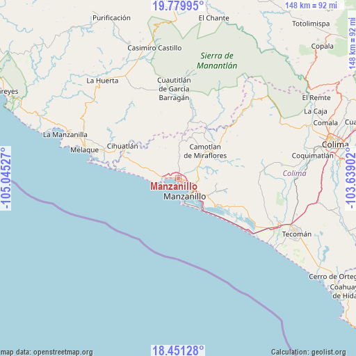
Manzanillo GPS coordinates[2]
19° 7' 1.02" North, 104° 20' 31.704" West
| Map corner | latitude | longitude |
|---|---|---|
| Upper-left | 19.77995°, | -105.04527° |
| Center: | 19.11695°, | -104.34214° |
| Lower-right: | 18.45128°, | -103.63902° |
| Map W x H: | 147.7×147.7 km | = 91.8×91.8mi |
| max Lat: | 32.7° ⇑62.8% North |
| Manzanillo: | 19.11695° |
| min Lat: | ⇓37.2% South 14.53588° |
| min Long | Manzanillo | max Long |
| -117.105° | -104.34214° | -86.73105° |
| W 9.3%⇐ | ⇒90.7% E |
Elevation
Elevation of Manzanillo is 12 m = 39 ft, and this is 1241.7 m = 4074 ft below average elevation for this country.
| Max E: |
3497 m = 11473 ft | 95.7% |
| Avg. | 1253.7 m = 4113 ft | |
| Manzanillo | 12 m = 39 ft | |
Min E: |
-1 m = -3 ft | 4.3% |
See also: Manzanillo elevation on elevation.city.
Geographical zone
Manzanillo is located in North Torrid zone (between Equator and Tropic of Cancer). Distance of this Northern Tropic circle is 480.3 km =298.4 mi to North.| Distance of | km | miles | from Manzanillo |
|---|---|---|---|
| North Pole | 7881.5 | 4897.3 | to North |
| Arctic Circle | 5275.6 | 3278.1 | to North |
| Tropic Cancer | 480.3 | 298.4 | to North |
| Equator | 2125.6 | 1320.8 | to South |


Nearby cities:
15 places around Manzanillo: (largest is in red/bold)
• Camotlán de Miraflores
16.1 km =10 mi,  44°
44°
• Cedros
21.5 km =13.4 mi,  30°
30°
• Chacala
24.2 km =15 mi,  14°
14°
• Chandiablo
9.1 km =5.7 mi,  1°
1°
• Chavarín
24.7 km =15.3 mi,  292°
292°
• El Colomo
10.8 km =6.7 mi,  125°
125°
• El Garcero
13.6 km =8.5 mi,  120°
120°
• El Naranjo
8.1 km =5 mi,  280°
280°
• Francisco Villa
8.6 km =5.3 mi,  95°
95°
• Jalipa
7.9 km =4.9 mi,  85°
85°
• La Central
10.5 km =6.5 mi, 285°
• Las Juntas (La Floreña)
14.2 km =8.8 mi, 118°
• Río Marabasco
23.3 km =14.5 mi,  302°
302°
• San Buenaventura
22.3 km =13.9 mi, 120°
• Tapeixtles
8.1 km =5 mi, 130°
Sources, notices
• [Note1] Compared only with cities in Mexico existing in our database
• [Src1] Map data: © OpenStreetMap contributors (CC-BY-SA)
• [Src2] Other city data from geonames.org with taken over terms of usage.
• [Src3] Geographical zone / Annual Mean Temperature by Robert A. Rohde @ Wikipedia
