San Blas geodata
San Blas (Nayarit) is a seat of a second-order administrative division; located in Mexico in America/Mazatlan (GMT-7) time zone. With population of 10,187 people, there are 934 cities with bigger population in this country. Compared to other cities in Mexico, 81.7% of cities are located further ↓South; 92.6% of cities are located further →East and 98.1% of cities have higher elevation than San Blas. Note1


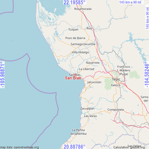
San Blas GPS coordinates[2]
21° 32' 35.988" North, 105° 17' 8.088" West
| Map corner | latitude | longitude |
|---|---|---|
| Upper-left | 22.19585°, | -105.98871° |
| Center: | 21.54333°, | -105.28558° |
| Lower-right: | 20.88786°, | -104.58246° |
| Map W x H: | 145.4×145.4 km | = 90.3×90.3mi |
| max Lat: | 32.7° ⇑18.3% North |
| San Blas: | 21.54333° |
| min Lat: | ⇓81.7% South 14.53588° |
| min Long | San Blas | max Long |
| -117.105° | -105.28558° | -86.73105° |
| W 7.4%⇐ | ⇒92.6% E |
Elevation
Elevation of San Blas is 8 m = 26 ft, and this is 1245.7 m = 4087 ft below average elevation for this country.
| Max E: |
3497 m = 11473 ft | 98.1% |
| Avg. | 1253.7 m = 4113 ft | |
| San Blas | 8 m = 26 ft | |
Min E: |
-1 m = -3 ft | 1.9% |
See also: Mexico elevation on elevation.city.
Geographical zone
San Blas is located in North Torrid zone (between Equator and Tropic of Cancer). Distance of this Northern Tropic circle is 210.5 km =130.8 mi to North.| Distance of | km | miles | from San Blas |
|---|---|---|---|
| North Pole | 7611.7 | 4729.7 | to North |
| Arctic Circle | 5005.8 | 3110.5 | to North |
| Tropic Cancer | 210.5 | 130.8 | to North |
| Equator | 2395.4 | 1488.4 | to South |


Nearby cities:
15 places around San Blas: (largest is in red/bold)
• Aticama
11.2 km =7 mi,  126°
126°
• Aután
16.4 km =10.2 mi,  352°
352°
• Cañada del Tabaco
19.8 km =12.3 mi,  339°
339°
• El Llano
17.7 km =11 mi,  141°
141°
• El Madrigaleño
16.4 km =10.2 mi, 343°
• Guadalupe Victoria
15.8 km =9.8 mi, 344°
• Huaristemba
18.6 km =11.6 mi,  45°
45°
• La Bajada
13.9 km =8.6 mi,  108°
108°
• La Goma
19.3 km =12 mi,  3°
3°
• La Libertad
12.8 km =8 mi,  64°
64°
• La Palma
12.5 km =7.8 mi,  117°
117°
• Laureles y Góngora (El Limón)
16.2 km =10.1 mi,  319°
319°
• Mecatán
17.2 km =10.7 mi,  92°
92°
• Reforma Agraria
16.1 km =10 mi,  34°
34°
• Villa Juárez
19.5 km =12.1 mi,  326°
326°
Sources, notices
• [Note1] Compared only with cities in Mexico existing in our database
• [Src1] Map data: © OpenStreetMap contributors (CC-BY-SA)
• [Src2] Other city data from geonames.org with taken over terms of usage.
• [Src3] Geographical zone / Annual Mean Temperature by Robert A. Rohde @ Wikipedia
