El Madrigaleño geodata
El Madrigaleño (Nayarit) is a populated place; located in Mexico in America/Mazatlan (GMT-7) time zone. With population of 793 people, there are 11002 cities with bigger population in this country. Compared to other cities in Mexico, 82.4% of cities are located further ↓South; 92.8% of cities are located further →East and 98.7% of cities have higher elevation than El Madrigaleño. Note1


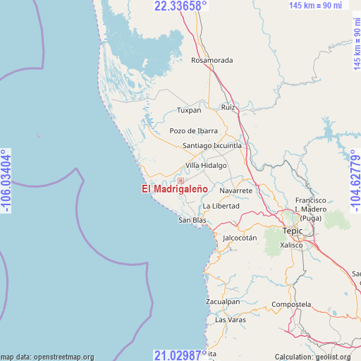
El Madrigaleño GPS coordinates[2]
21° 41' 4.956" North, 105° 19' 51.276" West
| Map corner | latitude | longitude |
|---|---|---|
| Upper-left | 22.33658°, | -106.03404° |
| Center: | 21.68471°, | -105.33091° |
| Lower-right: | 21.02987°, | -104.62779° |
| Map W x H: | 145.3×145.3 km | = 90.3×90.3mi |
| max Lat: | 32.7° ⇑17.6% North |
| El Madrigaleño: | 21.68471° |
| min Lat: | ⇓82.4% South 14.53588° |
| min Long | El Madrigaleño | max Long |
| -117.105° | -105.33091° | -86.73105° |
| W 7.2%⇐ | ⇒92.8% E |
Elevation
Elevation of El Madrigaleño is 7 m = 23 ft, and this is 1246.7 m = 4090 ft below average elevation for this country.
| Max E: |
3497 m = 11473 ft | 98.7% |
| Avg. | 1253.7 m = 4113 ft | |
| El Madrigaleño | 7 m = 23 ft | |
Min E: |
-1 m = -3 ft | 1.3% |
See also: Mexico elevation on elevation.city.
Geographical zone
El Madrigaleño is located in North Torrid zone (between Equator and Tropic of Cancer). Distance of this Northern Tropic circle is 194.8 km =121 mi to North.| Distance of | km | miles | from El Madrigaleño |
|---|---|---|---|
| North Pole | 7595.9 | 4719.9 | to North |
| Arctic Circle | 4990.1 | 3100.7 | to North |
| Tropic Cancer | 194.8 | 121 | to North |
| Equator | 2411.1 | 1498.2 | to South |


Nearby cities:
15 places around El Madrigaleño: (largest is in red/bold)
• Aután
2.5 km =1.6 mi,  77°
77°
• Cañada del Tabaco
3.7 km =2.3 mi,  319°
319°
• Cerritos
12.4 km =7.7 mi,  29°
29°
• El Botadero
9 km =5.6 mi, 30°
• El Corte
9.7 km =6 mi,  66°
66°
• Gavilán Grande
13.3 km =8.3 mi,  17°
17°
• Guadalupe Victoria
0.7 km =0.4 mi,  147°
147°
• La Goma
6.7 km =4.2 mi,  58°
58°
• Laureles y Góngora (El Limón)
6.6 km =4.1 mi,  239°
239°
• Los Otates
5.2 km =3.2 mi,  294°
294°
• Pueblo Nuevo
10 km =6.2 mi,  12°
12°
• Puerta de Mangos
3.8 km =2.4 mi,  353°
353°
• Sentispac
13.4 km =8.3 mi, 353°
• Villa Hidalgo
12.1 km =7.5 mi, 58°
• Villa Juárez
6.1 km =3.8 mi,  274°
274°
Sources, notices
• [Note1] Compared only with cities in Mexico existing in our database
• [Src1] Map data: © OpenStreetMap contributors (CC-BY-SA)
• [Src2] Other city data from geonames.org with taken over terms of usage.
• [Src3] Geographical zone / Annual Mean Temperature by Robert A. Rohde @ Wikipedia
