La Bajada geodata
La Bajada (Nayarit) is a populated place; located in Mexico in America/Mazatlan (GMT-7) time zone. With population of 537 people, there are 15796 cities with bigger population in this country. Compared to other cities in Mexico, 81.4% of cities are located further ↓South; 92.2% of cities are located further →East and 76.5% of cities have higher elevation than La Bajada. Note1


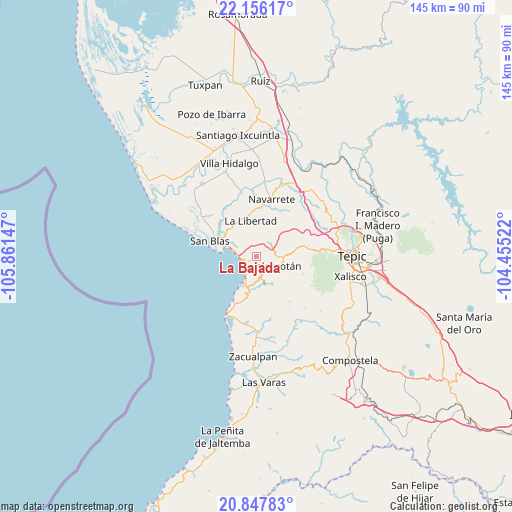
La Bajada GPS coordinates[2]
21° 30' 12.492" North, 105° 9' 30.024" West
| Map corner | latitude | longitude |
|---|---|---|
| Upper-left | 22.15617°, | -105.86147° |
| Center: | 21.50347°, | -105.15834° |
| Lower-right: | 20.84783°, | -104.45522° |
| Map W x H: | 145.5×145.5 km | = 90.4×90.4mi |
| max Lat: | 32.7° ⇑18.6% North |
| La Bajada: | 21.50347° |
| min Lat: | ⇓81.4% South 14.53588° |
| min Long | La Bajada | max Long |
| -117.105° | -105.15834° | -86.73105° |
| W 7.8%⇐ | ⇒92.2% E |
Elevation
Elevation of La Bajada is 168 m = 551 ft, and this is 1085.7 m = 3562 ft below average elevation for this country.
| Max E: |
3497 m = 11473 ft | 76.5% |
| Avg. | 1253.7 m = 4113 ft | |
| La Bajada | 168 m = 551 ft | |
Min E: |
-1 m = -3 ft | 23.5% |
See also: Mexico elevation on elevation.city.
Geographical zone
La Bajada is located in North Torrid zone (between Equator and Tropic of Cancer). Distance of this Northern Tropic circle is 215 km =133.6 mi to North.| Distance of | km | miles | from La Bajada |
|---|---|---|---|
| North Pole | 7616.1 | 4732.4 | to North |
| Arctic Circle | 5010.2 | 3113.2 | to North |
| Tropic Cancer | 215 | 133.6 | to North |
| Equator | 2391 | 1485.7 | to South |


Nearby cities:
15 places around La Bajada: (largest is in red/bold)
• Aticama
4.6 km =2.9 mi,  241°
241°
• Cuarenteño
14.2 km =8.8 mi,  110°
110°
• El Llano
9.7 km =6 mi,  193°
193°
• El Malinal
20.3 km =12.6 mi,  136°
136°
• El Trapichillo
19.7 km =12.2 mi,  67°
67°
• Huaristemba
17.4 km =10.8 mi,  0°
0°
• Jalcocotán
6.7 km =4.2 mi, 111°
• La Libertad
10.1 km =6.3 mi,  351°
351°
• La Palma
2.4 km =1.5 mi, 237°
• La Yerba
11.4 km =7.1 mi,  79°
79°
• Mecatán
5.4 km =3.4 mi,  47°
47°
• Navarrete
16.7 km =10.4 mi,  15°
15°
• Otates y Cantarranas
19.2 km =11.9 mi, 187°
• Reforma Agraria
18.1 km =11.2 mi, 347°
• San Blas
13.9 km =8.6 mi,  288°
288°
Sources, notices
• [Note1] Compared only with cities in Mexico existing in our database
• [Src1] Map data: © OpenStreetMap contributors (CC-BY-SA)
• [Src2] Other city data from geonames.org with taken over terms of usage.
• [Src3] Geographical zone / Annual Mean Temperature by Robert A. Rohde @ Wikipedia
