Reforma Agraria geodata
Reforma Agraria (Nayarit) is a populated place; located in Mexico in America/Mazatlan (GMT-7) time zone. With population of 561 people, there are 15205 cities with bigger population in this country. Compared to other cities in Mexico, 82.2% of cities are located further ↓South; 92.3% of cities are located further →East and 96.3% of cities have higher elevation than Reforma Agraria. Note1


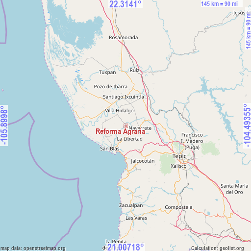
Reforma Agraria GPS coordinates[2]
21° 39' 43.632" North, 105° 11' 48.012" West
| Map corner | latitude | longitude |
|---|---|---|
| Upper-left | 22.3141°, | -105.8998° |
| Center: | 21.66212°, | -105.19667° |
| Lower-right: | 21.00718°, | -104.49355° |
| Map W x H: | 145.3×145.3 km | = 90.3×90.3mi |
| max Lat: | 32.7° ⇑17.8% North |
| Reforma Agraria: | 21.66212° |
| min Lat: | ⇓82.2% South 14.53588° |
| min Long | Reforma Agraria | max Long |
| -117.105° | -105.19667° | -86.73105° |
| W 7.7%⇐ | ⇒92.3% E |
Elevation
Elevation of Reforma Agraria is 11 m = 36 ft, and this is 1242.7 m = 4077 ft below average elevation for this country.
| Max E: |
3497 m = 11473 ft | 96.3% |
| Avg. | 1253.7 m = 4113 ft | |
| Reforma Agraria | 11 m = 36 ft | |
Min E: |
-1 m = -3 ft | 3.7% |
See also: Mexico elevation on elevation.city.
Geographical zone
Reforma Agraria is located in North Torrid zone (between Equator and Tropic of Cancer). Distance of this Northern Tropic circle is 197.3 km =122.6 mi to North.| Distance of | km | miles | from Reforma Agraria |
|---|---|---|---|
| North Pole | 7598.5 | 4721.5 | to North |
| Arctic Circle | 4992.6 | 3102.3 | to North |
| Tropic Cancer | 197.3 | 122.6 | to North |
| Equator | 2408.6 | 1496.6 | to South |


Nearby cities:
15 places around Reforma Agraria: (largest is in red/bold)
• Amapa
14.8 km =9.2 mi,  336°
336°
• Aután
11.9 km =7.4 mi,  285°
285°
• Cerritos
15.4 km =9.6 mi,  329°
329°
• Cinco de Mayo
11.7 km =7.3 mi,  74°
74°
• El Botadero
13.8 km =8.6 mi,  317°
317°
• El Corte
8.2 km =5.1 mi, 322°
• El Madrigaleño
14.1 km =8.8 mi,  280°
280°
• Guadalupe Victoria
13.7 km =8.5 mi, 278°
• Huaristemba
4.1 km =2.5 mi,  93°
93°
• La Goma
10.1 km =6.3 mi,  306°
306°
• La Libertad
8 km =5 mi,  162°
162°
• Leandro B. Flores
12.9 km =8 mi,  11°
11°
• Navarrete
8.5 km =5.3 mi,  100°
100°
• Sauta
8.6 km =5.3 mi,  40°
40°
• Villa Hidalgo
9.5 km =5.9 mi, 338°
Sources, notices
• [Note1] Compared only with cities in Mexico existing in our database
• [Src1] Map data: © OpenStreetMap contributors (CC-BY-SA)
• [Src2] Other city data from geonames.org with taken over terms of usage.
• [Src3] Geographical zone / Annual Mean Temperature by Robert A. Rohde @ Wikipedia
