La Goma geodata
La Goma (Nayarit) is a populated place; located in Mexico in America/Mazatlan (GMT-7) time zone. With population of 533 people, there are 15888 cities with bigger population in this country. Compared to other cities in Mexico, 82.5% of cities are located further ↓South; 92.6% of cities are located further →East and 97% of cities have higher elevation than La Goma. Note1


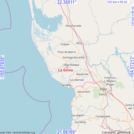
La Goma GPS coordinates[2]
21° 42' 58.968" North, 105° 16' 30.9" West
| Map corner | latitude | longitude |
|---|---|---|
| Upper-left | 22.36811°, | -105.97838° |
| Center: | 21.71638°, | -105.27525° |
| Lower-right: | 21.06169°, | -104.57213° |
| Map W x H: | 145.3×145.3 km | = 90.3×90.3mi |
| max Lat: | 32.7° ⇑17.5% North |
| La Goma: | 21.71638° |
| min Lat: | ⇓82.5% South 14.53588° |
| min Long | La Goma | max Long |
| -117.105° | -105.27525° | -86.73105° |
| W 7.4%⇐ | ⇒92.6% E |
Elevation
Elevation of La Goma is 10 m = 33 ft, and this is 1243.7 m = 4080 ft below average elevation for this country.
| Max E: |
3497 m = 11473 ft | 97% |
| Avg. | 1253.7 m = 4113 ft | |
| La Goma | 10 m = 33 ft | |
Min E: |
-1 m = -3 ft | 3% |
See also: Mexico elevation on elevation.city.
Geographical zone
La Goma is located in North Torrid zone (between Equator and Tropic of Cancer). Distance of this Northern Tropic circle is 191.3 km =118.9 mi to North.| Distance of | km | miles | from La Goma |
|---|---|---|---|
| North Pole | 7592.4 | 4717.7 | to North |
| Arctic Circle | 4986.5 | 3098.5 | to North |
| Tropic Cancer | 191.3 | 118.9 | to North |
| Equator | 2414.6 | 1500.4 | to South |


Nearby cities:
15 places around La Goma: (largest is in red/bold)
• Amapa
7.8 km =4.8 mi,  15°
15°
• Aután
4.5 km =2.8 mi,  228°
228°
• Cañada del Tabaco
8.2 km =5.1 mi,  264°
264°
• Cerritos
7.2 km =4.5 mi,  2°
2°
• El Botadero
4.3 km =2.7 mi,  344°
344°
• El Corte
3.2 km =2 mi,  82°
82°
• El Madrigaleño
6.7 km =4.2 mi,  238°
238°
• Gavilán Grande
9.4 km =5.8 mi,  348°
348°
• Guadalupe Victoria
6.8 km =4.2 mi, 232°
• La Presa
12.1 km =7.5 mi,  39°
39°
• Los Otates
10.5 km =6.5 mi, 262°
• Pueblo Nuevo
7.1 km =4.4 mi,  330°
330°
• Puerta de Mangos
6.2 km =3.9 mi,  272°
272°
• Reforma Agraria
10.1 km =6.3 mi,  126°
126°
• Villa Hidalgo
5.4 km =3.4 mi,  58°
58°
Sources, notices
• [Note1] Compared only with cities in Mexico existing in our database
• [Src1] Map data: © OpenStreetMap contributors (CC-BY-SA)
• [Src2] Other city data from geonames.org with taken over terms of usage.
• [Src3] Geographical zone / Annual Mean Temperature by Robert A. Rohde @ Wikipedia
