San Andrés geodata
San Andrés (Jalisco) is a populated place; located in Mexico in America/Mexico_City (GMT-6) time zone. With population of 717 people, there are 12151 cities with bigger population in this country. Compared to other cities in Mexico, 64.3% of cities are located further ↓South; 85% of cities are located further →East and 52.6% of cities have lower elevation than San Andrés. Note1


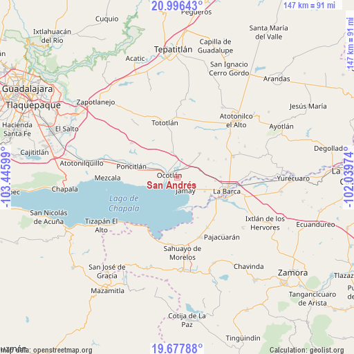
San Andrés GPS coordinates[2]
20° 20' 18.816" North, 102° 44' 34.296" West
| Map corner | latitude | longitude |
|---|---|---|
| Upper-left | 20.99643°, | -103.44599° |
| Center: | 20.33856°, | -102.74286° |
| Lower-right: | 19.67788°, | -102.03974° |
| Map W x H: | 146.6×146.6 km | = 91.1×91.1mi |
| max Lat: | 32.7° ⇑35.7% North |
| San Andrés: | 20.33856° |
| min Lat: | ⇓64.3% South 14.53588° |
| min Long | San Andrés | max Long |
| -117.105° | -102.74286° | -86.73105° |
| W 15%⇐ | ⇒85% E |
Elevation
Elevation of San Andrés is 1535 m = 5036 ft, and this is 281.3 m = 923 ft above average elevation for this country.
| Max E: |
3497 m = 11473 ft | 47.4% |
| San Andrés | 1535 m 5036 ft | |
| Avg. | 1253.7 m = 4113 ft | |
Min E: |
-1 m = -3 ft | 52.6% |
See also: Mexico elevation on elevation.city.
Geographical zone
San Andrés is located in North Torrid zone (between Equator and Tropic of Cancer). Distance of this Northern Tropic circle is 344.5 km =214.1 mi to North.| Distance of | km | miles | from San Andrés |
|---|---|---|---|
| North Pole | 7745.6 | 4812.9 | to North |
| Arctic Circle | 5139.7 | 3193.7 | to North |
| Tropic Cancer | 344.5 | 214.1 | to North |
| Equator | 2261.4 | 1405.2 | to South |


Nearby cities:
15 places around San Andrés: (largest is in red/bold)
• Canales
15 km =9.3 mi,  60°
60°
• Cuitzeo (La Estancia)
4.3 km =2.7 mi,  276°
276°
• Jamay
6.2 km =3.9 mi,  143°
143°
• Joconoxtle (La Tuna)
14.4 km =8.9 mi,  28°
28°
• La Providencia
12.5 km =7.8 mi,  108°
108°
• Ocotlán
3.7 km =2.3 mi,  300°
300°
• Otatlán
13 km =8.1 mi,  330°
330°
• San Agustín
12.9 km =8 mi,  117°
117°
• San José de las Moras
15.7 km =9.8 mi,  95°
95°
• San Luis de Agua Caliente
9.8 km =6.1 mi, 300°
• San Martín de Zula
8 km =5 mi,  11°
11°
• San Miguel de la Paz
9.1 km =5.7 mi,  66°
66°
• San Vicente
13.6 km =8.5 mi,  42°
42°
• Santa Clara de Zula
8.3 km =5.2 mi,  19°
19°
• Santa Cruz el Grande
13.2 km =8.2 mi,  287°
287°
Sources, notices
• [Note1] Compared only with cities in Mexico existing in our database
• [Src1] Map data: © OpenStreetMap contributors (CC-BY-SA)
• [Src2] Other city data from geonames.org with taken over terms of usage.
• [Src3] Geographical zone / Annual Mean Temperature by Robert A. Rohde @ Wikipedia
