Santa Cruz el Grande geodata
Santa Cruz el Grande (Jalisco) is a populated place; located in Mexico in America/Mexico_City (GMT-6) time zone. With population of 2,800 people, there are 3165 cities with bigger population in this country. Compared to other cities in Mexico, 65.1% of cities are located further ↓South; 85.3% of cities are located further →East and 52.5% of cities have lower elevation than Santa Cruz el Grande. Note1
Current local time in Santa Cruz el Grande:
03:40 AM, WednesdayDifference from your time zone: hours


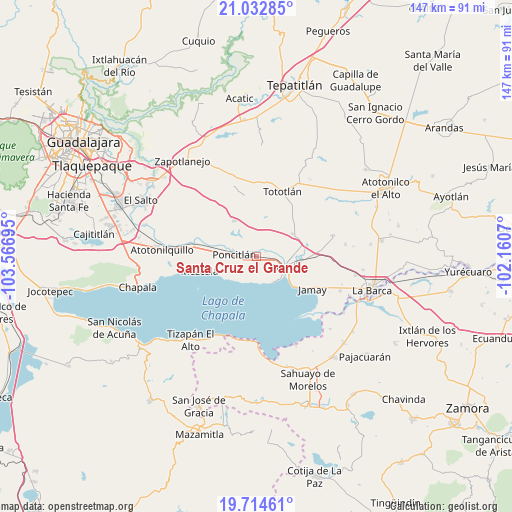
Santa Cruz el Grande GPS coordinates[2]
20° 22' 30.504" North, 102° 51' 49.752" West
| Map corner | latitude | longitude |
|---|---|---|
| Upper-left | 21.03285°, | -103.56695° |
| Center: | 20.37514°, | -102.86382° |
| Lower-right: | 19.71461°, | -102.1607° |
| Map W x H: | 146.6×146.6 km | = 91.1×91.1mi |
| max Lat: | 32.7° ⇑34.9% North |
| Santa Cruz el Grande: | 20.37514° |
| min Lat: | ⇓65.1% South 14.53588° |
| min Long | Santa Cruz el G | max Long |
| -117.105° | -102.86382° | -86.73105° |
| W 14.7%⇐ | ⇒85.3% E |
Elevation
Elevation of Santa Cruz el Grande is 1533 m = 5030 ft, and this is 279.3 m = 916 ft above average elevation for this country.
| Max E: |
3497 m = 11473 ft | 47.5% |
| Santa Cruz el Grande | 1533 m 5030 ft | |
| Avg. | 1253.7 m = 4113 ft | |
Min E: |
-1 m = -3 ft | 52.5% |
See also: Mexico elevation on elevation.city.
Geographical zone
Santa Cruz el Grande is located in North Torrid zone (between Equator and Tropic of Cancer). Distance of this Northern Tropic circle is 340.4 km =211.5 mi to North.| Distance of | km | miles | from Santa Cruz el Grande |
|---|---|---|---|
| North Pole | 7741.6 | 4810.4 | to North |
| Arctic Circle | 5135.7 | 3191.2 | to North |
| Tropic Cancer | 340.4 | 211.5 | to North |
| Equator | 2265.5 | 1407.7 | to South |


Nearby cities:
15 places around Santa Cruz el Grande: (largest is in red/bold)
• Ahuatlán
5.4 km =3.4 mi,  332°
332°
• Chalpicote
9.1 km =5.7 mi,  216°
216°
• Cuitzeo (La Estancia)
9.1 km =5.7 mi,  113°
113°
• El Romereño (INFONAVIT)
8.9 km =5.5 mi,  274°
274°
• El Sauz
13.2 km =8.2 mi,  29°
29°
• La Colonia
9.1 km =5.7 mi,  309°
309°
• La Noria
9.1 km =5.7 mi,  11°
11°
• La Zapotera
8.5 km =5.3 mi,  204°
204°
• Ocotlán
9.7 km =6 mi,  103°
103°
• Otatlán
9.6 km =6 mi,  40°
40°
• Poncitlán
6.5 km =4 mi, 274°
• San Andrés
13.2 km =8.2 mi, 107°
• San Luis de Agua Caliente
4.2 km =2.6 mi,  77°
77°
• San Pedro Itzicán
11.4 km =7.1 mi,  235°
235°
• Zapotlán del Rey
12 km =7.5 mi, 327°
Sources, notices
• [Note1] Compared only with cities in Mexico existing in our database
• [Src1] Map data: © OpenStreetMap contributors (CC-BY-SA)
• [Src2] Other city data from geonames.org with taken over terms of usage.
• [Src3] Geographical zone / Annual Mean Temperature by Robert A. Rohde @ Wikipedia
