General Cepeda geodata
General Cepeda (Coahuila) is a seat of a second-order administrative division; located in Mexico in America/Monterrey (GMT-6) time zone. With population of 4,382 people, there are 2089 cities with bigger population in this country. Compared to other cities in Mexico, 92.3% of cities are located further ↓South; 77.2% of cities are located further →East and 50.7% of cities have lower elevation than General Cepeda. Note1


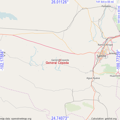
General Cepeda GPS coordinates[2]
25° 22' 39.612" North, 101° 28' 32.556" West
| Map corner | latitude | longitude |
|---|---|---|
| Upper-left | 26.01126°, | -102.17884° |
| Center: | 25.37767°, | -101.47571° |
| Lower-right: | 24.74073°, | -100.77259° |
| Map W x H: | 141.3×141.3 km | = 87.8×87.8mi |
| max Lat: | 32.7° ⇑7.7% North |
| General Cepeda: | 25.37767° |
| min Lat: | ⇓92.3% South 14.53588° |
| min Long | General Cepeda | max Long |
| -117.105° | -101.47571° | -86.73105° |
| W 22.8%⇐ | ⇒77.2% E |
Elevation
Elevation of General Cepeda is 1468 m = 4816 ft, and this is 214.3 m = 703 ft above average elevation for this country.
| Max E: |
3497 m = 11473 ft | 49.3% |
| General Cepeda | 1468 m 4816 ft | |
| Avg. | 1253.7 m = 4113 ft | |
Min E: |
-1 m = -3 ft | 50.7% |
See also: Mexico elevation on elevation.city.
Geographical zone
General Cepeda is located in North temperate zone (between Tropic of Cancer and the Arctic Circle). Distance of this Northern Tropic circle is 215.8 km =134.1 mi to South.| Distance of | km | miles | from General Cepeda |
|---|---|---|---|
| North Pole | 7185.3 | 4464.7 | to North |
| Arctic Circle | 4579.4 | 2845.5 | to North |
| Tropic Cancer | 215.8 | 134.1 | to South |
| Equator | 2821.7 | 1753.3 | to South |


Nearby cities:
15 places around General Cepeda: (largest is in red/bold)
• Agua Nueva
44.2 km =27.5 mi,  118°
118°
• Arteaga
63.6 km =39.5 mi,  83°
83°
• Cuatro de Octubre
59 km =36.7 mi, 82°
• Derramadero
21.7 km =13.5 mi, 116°
• Huachichil
67.9 km =42.2 mi,  105°
105°
• Mazapil
82.6 km =51.3 mi,  185°
185°
• Melchor Ocampo
63 km =39.1 mi,  195°
195°
• Parras de la Fuente
70.9 km =44.1 mi,  275°
275°
• Puerto México
79.9 km =49.6 mi, 105°
• Ramos Arizpe
56 km =34.8 mi,  71°
71°
• Saltillo
47.5 km =29.5 mi, 83°
• San Francisco del Progreso
73.7 km =45.8 mi,  288°
288°
• San Juan de la Vaquería
29.2 km =18.1 mi, 118°
• Terminal de Providencia
76.2 km =47.3 mi,  179°
179°
• Veintiocho de Agosto
70.3 km =43.7 mi,  295°
295°
Sources, notices
• [Note1] Compared only with cities in Mexico existing in our database
• [Src1] Map data: © OpenStreetMap contributors (CC-BY-SA)
• [Src2] Other city data from geonames.org with taken over terms of usage.
• [Src3] Geographical zone / Annual Mean Temperature by Robert A. Rohde @ Wikipedia
