Derramadero geodata
Derramadero (Coahuila) is a populated place; located in Mexico in America/Monterrey (GMT-6) time zone. With population of 879 people, there are 9939 cities with bigger population in this country. Compared to other cities in Mexico, 92.2% of cities are located further ↓South; 75.5% of cities are located further →East and 62.2% of cities have lower elevation than Derramadero. Note1


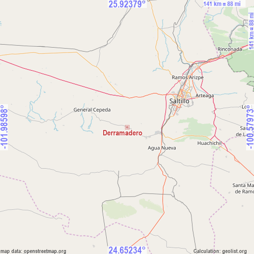
Derramadero GPS coordinates[2]
25° 17' 23.028" North, 101° 16' 58.26" West
| Map corner | latitude | longitude |
|---|---|---|
| Upper-left | 25.92379°, | -101.98598° |
| Center: | 25.28973°, | -101.28285° |
| Lower-right: | 24.65234°, | -100.57973° |
| Map W x H: | 141.4×141.4 km | = 87.9×87.9mi |
| max Lat: | 32.7° ⇑7.8% North |
| Derramadero: | 25.28973° |
| min Lat: | ⇓92.2% South 14.53588° |
| min Long | Derramadero | max Long |
| -117.105° | -101.28285° | -86.73105° |
| W 24.5%⇐ | ⇒75.5% E |
Elevation
Elevation of Derramadero is 1763 m = 5784 ft, and this is 509.3 m = 1671 ft above average elevation for this country.
| Max E: |
3497 m = 11473 ft | 37.8% |
| Derramadero | 1763 m 5784 ft | |
| Avg. | 1253.7 m = 4113 ft | |
Min E: |
-1 m = -3 ft | 62.2% |
See also: Mexico elevation on elevation.city.
Geographical zone
Derramadero is located in North temperate zone (between Tropic of Cancer and the Arctic Circle). Distance of this Northern Tropic circle is 206 km =128 mi to South.| Distance of | km | miles | from Derramadero |
|---|---|---|---|
| North Pole | 7195.1 | 4470.8 | to North |
| Arctic Circle | 4589.2 | 2851.6 | to North |
| Tropic Cancer | 206 | 128 | to South |
| Equator | 2812 | 1747.3 | to South |


Nearby cities:
15 places around Derramadero: (largest is in red/bold)
• Agua Nueva
22.5 km =14 mi,  119°
119°
• Aquiles Serdán (La Hediondilla)
67.8 km =42.1 mi, 122°
• Arteaga
47.1 km =29.3 mi,  68°
68°
• Cuatro de Octubre
42.8 km =26.6 mi, 66°
• El Tunal
66.7 km =41.4 mi,  77°
77°
• General Cepeda
21.7 km =13.5 mi,  296°
296°
• Huachichil
46.8 km =29.1 mi,  100°
100°
• Los Lirios
70.8 km =44 mi, 80°
• Melchor Ocampo
62.6 km =38.9 mi,  215°
215°
• Puerto México
58.8 km =36.5 mi, 102°
• Ramos Arizpe
43.6 km =27.1 mi,  50°
50°
• Saltillo
31.6 km =19.6 mi,  61°
61°
• San Antonio de las Alazanas
70.9 km =44.1 mi,  91°
91°
• San Juan de la Vaquería
7.5 km =4.7 mi, 123°
• Terminal de Providencia
68.9 km =42.8 mi,  195°
195°
Sources, notices
• [Note1] Compared only with cities in Mexico existing in our database
• [Src1] Map data: © OpenStreetMap contributors (CC-BY-SA)
• [Src2] Other city data from geonames.org with taken over terms of usage.
• [Src3] Geographical zone / Annual Mean Temperature by Robert A. Rohde @ Wikipedia
