Potrerillos geodata
Potrerillos (Jalisco) is a populated place; located in Mexico in America/Mexico_City (GMT-6) time zone. With population of 1,542 people, there are 5597 cities with bigger population in this country. Compared to other cities in Mexico, 64.3% of cities are located further ↓South; 87.7% of cities are located further →East and 65.6% of cities have lower elevation than Potrerillos. Note1


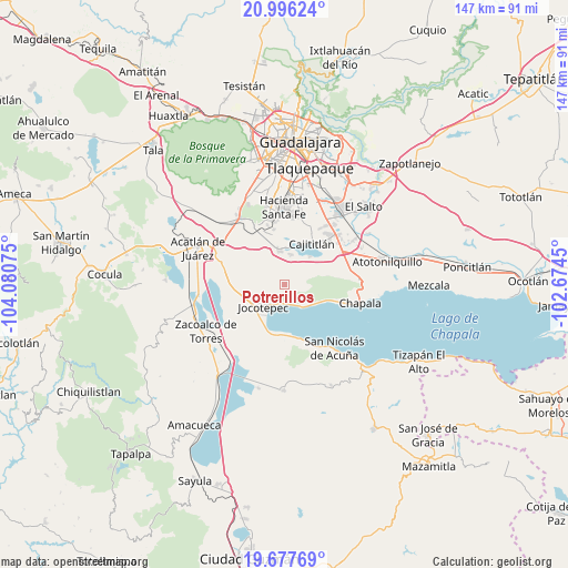
Potrerillos GPS coordinates[2]
20° 20' 18.132" North, 103° 22' 39.432" West
| Map corner | latitude | longitude |
|---|---|---|
| Upper-left | 20.99624°, | -104.08075° |
| Center: | 20.33837°, | -103.37762° |
| Lower-right: | 19.67769°, | -102.6745° |
| Map W x H: | 146.6×146.6 km | = 91.1×91.1mi |
| max Lat: | 32.7° ⇑35.7% North |
| Potrerillos: | 20.33837° |
| min Lat: | ⇓64.3% South 14.53588° |
| min Long | Potrerillos | max Long |
| -117.105° | -103.37762° | -86.73105° |
| W 12.3%⇐ | ⇒87.7% E |
Elevation
Elevation of Potrerillos is 1844 m = 6050 ft, and this is 590.3 m = 1937 ft above average elevation for this country.
| Max E: |
3497 m = 11473 ft | 34.4% |
| Potrerillos | 1844 m 6050 ft | |
| Avg. | 1253.7 m = 4113 ft | |
Min E: |
-1 m = -3 ft | 65.6% |
See also: Mexico elevation on elevation.city.
Geographical zone
Potrerillos is located in North Torrid zone (between Equator and Tropic of Cancer). Distance of this Northern Tropic circle is 344.5 km =214.1 mi to North.| Distance of | km | miles | from Potrerillos |
|---|---|---|---|
| North Pole | 7745.6 | 4812.9 | to North |
| Arctic Circle | 5139.8 | 3193.7 | to North |
| Tropic Cancer | 344.5 | 214.1 | to North |
| Equator | 2261.4 | 1405.2 | to South |


Nearby cities:
15 places around Potrerillos: (largest is in red/bold)
• Ajijic
13.4 km =8.3 mi,  106°
106°
• Cajititlán
12.6 km =7.8 mi,  34°
34°
• Cima del Sol (Fraccionamiento Cima del Sol)
15.1 km =9.4 mi,  344°
344°
• Cuexcomatitlán
10.1 km =6.3 mi,  9°
9°
• Galaxia la Noria
13.9 km =8.6 mi, 341°
• Huejotitán
11.6 km =7.2 mi,  279°
279°
• Jocotepec
8 km =5 mi,  222°
222°
• Las Trojes
5.1 km =3.2 mi,  94°
94°
• Lomas de Tejeda
14.5 km =9 mi,  349°
349°
• San Cristóbal Zapotitlán
12.7 km =7.9 mi,  176°
176°
• San Juan Cosalá
6.8 km =4.2 mi,  146°
146°
• San Lucas Evangelista
8 km =5 mi, 12°
• San Miguel Cuyutlán
8.8 km =5.5 mi, 351°
• San Pedro Tesistán
13 km =8.1 mi,  197°
197°
• Zapotitán de Hidalgo
10.6 km =6.6 mi,  262°
262°
Sources, notices
• [Note1] Compared only with cities in Mexico existing in our database
• [Src1] Map data: © OpenStreetMap contributors (CC-BY-SA)
• [Src2] Other city data from geonames.org with taken over terms of usage.
• [Src3] Geographical zone / Annual Mean Temperature by Robert A. Rohde @ Wikipedia
